Tâmna geodata
Tâmna (Mehedinţi) is a seat of a second-order administrative division; located in Romania in Europe/Bucharest (GMT+3) time zone. With population of 3,656 people, there are 1348 cities with bigger population in this country. Compared to other cities in Romania, 83.8% of cities are located further ↑North; 84.2% of cities are located further →East and 52.8% of cities have lower elevation than Tâmna. Note1


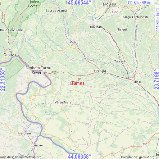
Tâmna GPS coordinates[2]
44° 34' 0.012" North, 23° 1' 0.012" East
| Map corner | latitude | longitude |
|---|---|---|
| Upper-left | 45.06544°, | 22.31355° |
| Center: | 44.56667°, | 23.01667° |
| Lower-right: | 44.06358°, | 23.7198° |
| Map W x H: | 111.4×111.4 km | = 69.2×69.2mi |
| max Lat: | 48.23793° ⇑83.8% North |
| Tâmna: | 44.56667° |
| min Lat: | ⇓16.2% South 43.65638° |
| min Long | Tâmna | max Long |
| 20.31667° | 23.01667° | 29.65403° |
| W 15.8%⇐ | ⇒84.2% E |
Elevation
Elevation of Tâmna is 226 m = 741 ft, and this is 28.9 m = 95 ft below average elevation for this country.
| Max E: |
1278 m = 4193 ft | 47.2% |
| Avg. | 254.9 m = 836 ft | |
| Tâmna | 226 m = 741 ft | |
Min E: |
-2 m = -7 ft | 52.8% |
See also: Romania elevation on elevation.city.
Geographical zone
Tâmna is located in North temperate zone (between Tropic of Cancer and the Arctic Circle). Distance of this Northern Tropic circle is 2349.4 km =1459.8 mi to South.| Distance of | km | miles | from Tâmna |
|---|---|---|---|
| North Pole | 5051.7 | 3139 | to North |
| Arctic Circle | 2445.8 | 1519.7 | to North |
| Tropic Cancer | 2349.4 | 1459.8 | to South |
| Equator | 4955.3 | 3079.1 | to South |


Nearby cities:
15 places around Tâmna: (largest is in red/bold)
• Bâcleș
13.1 km =8.1 mi,  135°
135°
• Ciochiuța
8.9 km =5.5 mi,  63°
63°
• Cordun
13.5 km =8.4 mi,  9°
9°
• Cotoroaia
9.3 km =5.8 mi, 8°
• Dumbrava de Sus
9.7 km =6 mi,  125°
125°
• Greci
8.1 km =5 mi,  103°
103°
• Iablanița
11.5 km =7.1 mi,  191°
191°
• Jirov
12.9 km =8 mi,  25°
25°
• Livezile
13.6 km =8.5 mi,  243°
243°
• Orevița Mare
14.7 km =9.1 mi,  213°
213°
• Poroina Mare
10.2 km =6.3 mi,  218°
218°
• Prunişor
9.3 km =5.8 mi,  300°
300°
• Stignița
8.3 km =5.2 mi, 188°
• Valea Ursului
4 km =2.5 mi,  49°
49°
• Voloiac
8.6 km =5.3 mi, 49°
Sources, notices
• [Note1] Compared only with cities in Romania existing in our database
• [Src1] Map data: © OpenStreetMap contributors (CC-BY-SA)
• [Src2] Other city data from geonames.org with taken over terms of usage.
• [Src3] Geographical zone / Annual Mean Temperature by Robert A. Rohde @ Wikipedia
