Vlăsineşti geodata
Vlăsineşti (Botoşani) is a seat of a second-order administrative division; located in Romania in Europe/Bucharest (GMT+3) time zone. With population of 3,380 people, there are 1501 cities with bigger population in this country. Compared to other cities in Romania, 98.4% of cities are located further ↓South; 80.6% of cities are located further ←West and 73.3% of cities have higher elevation than Vlăsineşti. Note1


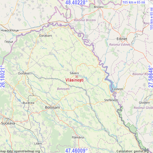
Vlăsineşti GPS coordinates[2]
47° 55' 59.988" North, 26° 52' 59.988" East
| Map corner | latitude | longitude |
|---|---|---|
| Upper-left | 48.40228°, | 26.18021° |
| Center: | 47.93333°, | 26.88333° |
| Lower-right: | 47.46009°, | 27.58646° |
| Map W x H: | 104.8×104.8 km | = 65.1×65.1mi |
| max Lat: | 48.23793° ⇑1.6% North |
| Vlăsineşti: | 47.93333° |
| min Lat: | ⇓98.4% South 43.65638° |
| min Long | Vlăsineşti | max Long |
| 20.31667° | 26.88333° | 29.65403° |
| W 80.6%⇐ | ⇒19.4% E |
Elevation
Elevation of Vlăsineşti is 116 m = 381 ft, and this is 138.9 m = 456 ft below average elevation for this country.
| Max E: |
1278 m = 4193 ft | 73.3% |
| Avg. | 254.9 m = 836 ft | |
| Vlăsineşti | 116 m = 381 ft | |
Min E: |
-2 m = -7 ft | 26.7% |
See also: Romania elevation on elevation.city.
Geographical zone
Vlăsineşti is located in North temperate zone (between Tropic of Cancer and the Arctic Circle). Distance of this North polar circle is 2071.5 km =1287.2 mi to North.| Distance of | km | miles | from Vlăsineşti |
|---|---|---|---|
| North Pole | 4677.4 | 2906.4 | to North |
| Arctic Circle | 2071.5 | 1287.2 | to North |
| Tropic Cancer | 2723.8 | 1692.5 | to South |
| Equator | 5329.7 | 3311.7 | to South |


Nearby cities:
15 places around Vlăsineşti: (largest is in red/bold)
• Aurel Vlaicu
7.8 km =4.8 mi,  15°
15°
• Borzești
9.9 km =6.2 mi,  255°
255°
• Chișcăreni
5 km =3.1 mi,  309°
309°
• Hăneşti
7.7 km =4.8 mi,  103°
103°
• Iacobeni
8.3 km =5.2 mi,  164°
164°
• Mihai Viteazu
7.5 km =4.7 mi,  265°
265°
• Petricani
3.9 km =2.4 mi, 310°
• Plopenii Mari
8.4 km =5.2 mi,  235°
235°
• Podriga
8.8 km =5.5 mi,  335°
335°
• Sârbi
2.8 km =1.7 mi,  68°
68°
• Săveni
2.2 km =1.4 mi,  326°
326°
• Ungureni
8.5 km =5.3 mi,  227°
227°
• Ungureni-Jianu
9.3 km =5.8 mi, 233°
• Vicoleni
6.5 km =4 mi,  203°
203°
• Ştiubieni
8.3 km =5.2 mi,  296°
296°
Sources, notices
• [Note1] Compared only with cities in Romania existing in our database
• [Src1] Map data: © OpenStreetMap contributors (CC-BY-SA)
• [Src2] Other city data from geonames.org with taken over terms of usage.
• [Src3] Geographical zone / Annual Mean Temperature by Robert A. Rohde @ Wikipedia
