Vășcăuți geodata
Vășcăuți (Suceava) is a populated place; located in Romania in Europe/Bucharest (GMT+3) time zone. With population of 604 people, there are 6177 cities with bigger population in this country. Compared to other cities in Romania, 99% of cities are located further ↓South; 63.5% of cities are located further ←West and 72.3% of cities have lower elevation than Vășcăuți. Note1


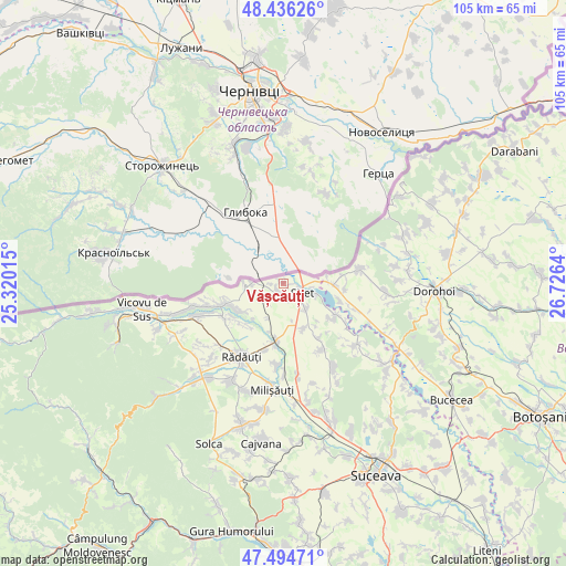
Vășcăuți GPS coordinates[2]
47° 58' 3.468" North, 26° 1' 23.772" East
| Map corner | latitude | longitude |
|---|---|---|
| Upper-left | 48.43626°, | 25.32015° |
| Center: | 47.96763°, | 26.02327° |
| Lower-right: | 47.49471°, | 26.7264° |
| Map W x H: | 104.7×104.7 km | = 65.1×65.1mi |
| max Lat: | 48.23793° ⇑1% North |
| Vășcăuți: | 47.96763° |
| min Lat: | ⇓99% South 43.65638° |
| min Long | Vășcăuți | max Long |
| 20.31667° | 26.02327° | 29.65403° |
| W 63.5%⇐ | ⇒36.5% E |
Elevation
Elevation of Vășcăuți is 336 m = 1102 ft, and this is 81.1 m = 266 ft above average elevation for this country.
| Max E: |
1278 m = 4193 ft | 27.7% |
| Vășcăuți | 336 m 1102 ft | |
| Avg. | 254.9 m = 836 ft | |
Min E: |
-2 m = -7 ft | 72.3% |
See also: Romania elevation on elevation.city.
Geographical zone
Vășcăuți is located in North temperate zone (between Tropic of Cancer and the Arctic Circle). Distance of this North polar circle is 2067.7 km =1284.8 mi to North.| Distance of | km | miles | from Vășcăuți |
|---|---|---|---|
| North Pole | 4673.6 | 2904 | to North |
| Arctic Circle | 2067.7 | 1284.8 | to North |
| Tropic Cancer | 2727.6 | 1694.9 | to South |
| Equator | 5333.5 | 3314.1 | to South |


Nearby cities:
15 places around Vășcăuți: (largest is in red/bold)
• Bălcăuţi
9.2 km =5.7 mi,  156°
156°
• Bălinești
13.8 km =8.6 mi,  123°
123°
• Cândeşti
13.7 km =8.5 mi,  106°
106°
• Dersca
13.3 km =8.3 mi,  82°
82°
• Dorneşti
10.8 km =6.7 mi,  187°
187°
• Frătăuţii Noi
13.6 km =8.5 mi,  258°
258°
• Frătăuţii Vechi
12.9 km =8 mi,  234°
234°
• Grămeşti
11 km =6.8 mi, 120°
• Mihăileni
9.4 km =5.8 mi,  90°
90°
• Muşeniţa
1.7 km =1.1 mi,  266°
266°
• Negostina
6.6 km =4.1 mi,  138°
138°
• Pârâu Negru
11.4 km =7.1 mi, 92°
• Pădureni
6.5 km =4 mi, 107°
• Rogojești
10.8 km =6.7 mi, 107°
• Siret
3.8 km =2.4 mi, 121°
Sources, notices
• [Note1] Compared only with cities in Romania existing in our database
• [Src1] Map data: © OpenStreetMap contributors (CC-BY-SA)
• [Src2] Other city data from geonames.org with taken over terms of usage.
• [Src3] Geographical zone / Annual Mean Temperature by Robert A. Rohde @ Wikipedia
