Negostina geodata
Negostina (Suceava) is a populated place; located in Romania in Europe/Bucharest (GMT+3) time zone. With population of 1,474 people, there are 3221 cities with bigger population in this country. Compared to other cities in Romania, 98.3% of cities are located further ↓South; 64.6% of cities are located further ←West and 75.2% of cities have lower elevation than Negostina. Note1


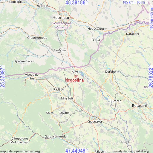
Negostina GPS coordinates[2]
47° 55' 22.152" North, 26° 4' 55.524" East
| Map corner | latitude | longitude |
|---|---|---|
| Upper-left | 48.39186°, | 25.37897° |
| Center: | 47.92282°, | 26.08209° |
| Lower-right: | 47.44949°, | 26.78522° |
| Map W x H: | 104.8×104.8 km | = 65.1×65.1mi |
| max Lat: | 48.23793° ⇑1.7% North |
| Negostina: | 47.92282° |
| min Lat: | ⇓98.3% South 43.65638° |
| min Long | Negostina | max Long |
| 20.31667° | 26.08209° | 29.65403° |
| W 64.6%⇐ | ⇒35.4% E |
Elevation
Elevation of Negostina is 354 m = 1161 ft, and this is 99.1 m = 325 ft above average elevation for this country.
| Max E: |
1278 m = 4193 ft | 24.8% |
| Negostina | 354 m 1161 ft | |
| Avg. | 254.9 m = 836 ft | |
Min E: |
-2 m = -7 ft | 75.2% |
See also: Romania elevation on elevation.city.
Geographical zone
Negostina is located in North temperate zone (between Tropic of Cancer and the Arctic Circle). Distance of this North polar circle is 2072.7 km =1287.9 mi to North.| Distance of | km | miles | from Negostina |
|---|---|---|---|
| North Pole | 4678.5 | 2907.1 | to North |
| Arctic Circle | 2072.7 | 1287.9 | to North |
| Tropic Cancer | 2722.6 | 1691.7 | to South |
| Equator | 5328.5 | 3311 | to South |


Nearby cities:
15 places around Negostina: (largest is in red/bold)
• Bălcăuţi
3.6 km =2.2 mi,  191°
191°
• Bălinești
7.6 km =4.7 mi,  109°
109°
• Calafindeşti
8.5 km =5.3 mi,  162°
162°
• Cândeşti
8.9 km =5.5 mi,  82°
82°
• Dersca
11.1 km =6.9 mi,  52°
52°
• Dorneşti
8.1 km =5 mi,  225°
225°
• Grămeşti
5.1 km =3.2 mi,  97°
97°
• Mihăileni
7 km =4.3 mi, 46°
• Muşeniţa
7.8 km =4.8 mi,  308°
308°
• Pârâu Negru
8.3 km =5.2 mi,  57°
57°
• Pădureni
3.5 km =2.2 mi,  30°
30°
• Rogojești
6.2 km =3.9 mi,  73°
73°
• Siret
3.2 km =2 mi,  339°
339°
• Vășcăuți
6.6 km =4.1 mi,  318°
318°
• Zamostea
10.8 km =6.7 mi,  125°
125°
Sources, notices
• [Note1] Compared only with cities in Romania existing in our database
• [Src1] Map data: © OpenStreetMap contributors (CC-BY-SA)
• [Src2] Other city data from geonames.org with taken over terms of usage.
• [Src3] Geographical zone / Annual Mean Temperature by Robert A. Rohde @ Wikipedia
