Mihăileni geodata
Mihăileni (Botoşani) is a seat of a second-order administrative division; located in Romania in Europe/Bucharest (GMT+3) time zone. With population of 5,037 people, there are 773 cities with bigger population in this country. Compared to other cities in Romania, 98.9% of cities are located further ↓South; 65.9% of cities are located further ←West and 71.7% of cities have lower elevation than Mihăileni. Note1


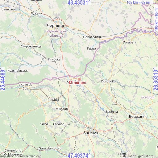
Mihăileni GPS coordinates[2]
47° 58' 0.012" North, 26° 9' 0" East
| Map corner | latitude | longitude |
|---|---|---|
| Upper-left | 48.43531°, | 25.44688° |
| Center: | 47.96667°, | 26.15° |
| Lower-right: | 47.49374°, | 26.85313° |
| Map W x H: | 104.7×104.7 km | = 65.1×65.1mi |
| max Lat: | 48.23793° ⇑1.1% North |
| Mihăileni: | 47.96667° |
| min Lat: | ⇓98.9% South 43.65638° |
| min Long | Mihăileni | max Long |
| 20.31667° | 26.15° | 29.65403° |
| W 65.9%⇐ | ⇒34.1% E |
Elevation
Elevation of Mihăileni is 332 m = 1089 ft, and this is 77.1 m = 253 ft above average elevation for this country.
| Max E: |
1278 m = 4193 ft | 28.3% |
| Mihăileni | 332 m 1089 ft | |
| Avg. | 254.9 m = 836 ft | |
Min E: |
-2 m = -7 ft | 71.7% |
See also: Romania elevation on elevation.city.
Geographical zone
Mihăileni is located in North temperate zone (between Tropic of Cancer and the Arctic Circle). Distance of this North polar circle is 2067.8 km =1284.9 mi to North.| Distance of | km | miles | from Mihăileni |
|---|---|---|---|
| North Pole | 4673.7 | 2904.1 | to North |
| Arctic Circle | 2067.8 | 1284.9 | to North |
| Tropic Cancer | 2727.5 | 1694.8 | to South |
| Equator | 5333.4 | 3314 | to South |


Nearby cities:
15 places around Mihăileni: (largest is in red/bold)
• Bălcăuţi
10.1 km =6.3 mi,  214°
214°
• Bălinești
7.7 km =4.8 mi,  164°
164°
• Cândeşti
5.3 km =3.3 mi,  134°
134°
• Dersca
4.2 km =2.6 mi,  63°
63°
• Grămeşti
5.6 km =3.5 mi,  180°
180°
• Hilişeu-Horia
10.5 km =6.5 mi,  45°
45°
• Hilișeu-Crișan
10.1 km =6.3 mi,  39°
39°
• Lozna
9.6 km =6 mi,  100°
100°
• Negostina
7 km =4.3 mi,  226°
226°
• Pârâu Negru
2 km =1.2 mi, 102°
• Pădureni
3.8 km =2.4 mi,  240°
240°
• Rogojești
3.2 km =2 mi, 163°
• Siret
6.5 km =4 mi,  253°
253°
• Talpa
9.7 km =6 mi,  138°
138°
• Vășcăuți
9.4 km =5.8 mi,  270°
270°
Sources, notices
• [Note1] Compared only with cities in Romania existing in our database
• [Src1] Map data: © OpenStreetMap contributors (CC-BY-SA)
• [Src2] Other city data from geonames.org with taken over terms of usage.
• [Src3] Geographical zone / Annual Mean Temperature by Robert A. Rohde @ Wikipedia
