Varnița geodata
Varnița (Prahova) is a populated place; located in Romania in Europe/Bucharest (GMT+3) time zone. With population of 1,092 people, there are 4011 cities with bigger population in this country. Compared to other cities in Romania, 76.4% of cities are located further ↑North; 61.8% of cities are located further ←West and 67% of cities have higher elevation than Varnița. Note1


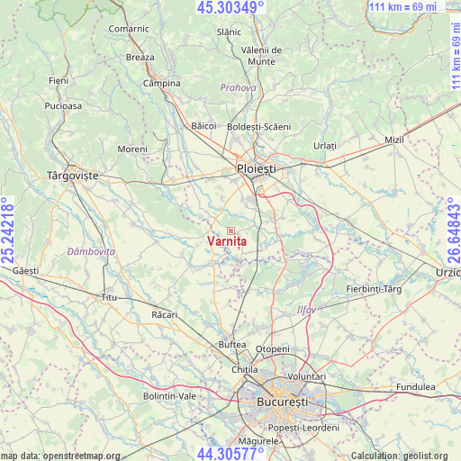
Varnița GPS coordinates[2]
44° 48' 24.444" North, 25° 56' 43.08" East
| Map corner | latitude | longitude |
|---|---|---|
| Upper-left | 45.30349°, | 25.24218° |
| Center: | 44.80679°, | 25.9453° |
| Lower-right: | 44.30577°, | 26.64843° |
| Map W x H: | 110.9×110.9 km | = 68.9×68.9mi |
| max Lat: | 48.23793° ⇑76.4% North |
| Varnița: | 44.80679° |
| min Lat: | ⇓23.6% South 43.65638° |
| min Long | Varnița | max Long |
| 20.31667° | 25.9453° | 29.65403° |
| W 61.8%⇐ | ⇒38.2% E |
Elevation
Elevation of Varnița is 139 m = 456 ft, and this is 115.9 m = 380 ft below average elevation for this country.
| Max E: |
1278 m = 4193 ft | 67% |
| Avg. | 254.9 m = 836 ft | |
| Varnița | 139 m = 456 ft | |
Min E: |
-2 m = -7 ft | 33% |
See also: Romania elevation on elevation.city.
Geographical zone
Varnița is located in North temperate zone (between Tropic of Cancer and the Arctic Circle). Distance of this Northern Tropic circle is 2376.1 km =1476.4 mi to South.| Distance of | km | miles | from Varnița |
|---|---|---|---|
| North Pole | 5025 | 3122.4 | to North |
| Arctic Circle | 2419.1 | 1503.2 | to North |
| Tropic Cancer | 2376.1 | 1476.4 | to South |
| Equator | 4982 | 3095.7 | to South |


Nearby cities:
15 places around Varnița: (largest is in red/bold)
• Brătești
2.4 km =1.5 mi,  256°
256°
• Cocorăștii Colț
4.7 km =2.9 mi,  310°
310°
• Cocorăștii Grind
7 km =4.3 mi, 309°
• Corneşti
6.7 km =4.2 mi,  247°
247°
• Frasinu
6.7 km =4.2 mi, 255°
• Hăbud
3.4 km =2.1 mi,  196°
196°
• Pisculești
6.2 km =3.9 mi,  66°
66°
• Postârnacu
5 km =3.1 mi,  282°
282°
• Predești
4 km =2.5 mi,  95°
95°
• Stejaru
3.7 km =2.3 mi,  19°
19°
• Stăncești
5.9 km =3.7 mi,  336°
336°
• Tinosu
5.7 km =3.5 mi,  78°
78°
• Tăriceni
2.2 km =1.4 mi,  121°
121°
• Ungureni
4.3 km =2.7 mi,  235°
235°
• Şirna
0.8 km =0.5 mi,  153°
153°
Sources, notices
• [Note1] Compared only with cities in Romania existing in our database
• [Src1] Map data: © OpenStreetMap contributors (CC-BY-SA)
• [Src2] Other city data from geonames.org with taken over terms of usage.
• [Src3] Geographical zone / Annual Mean Temperature by Robert A. Rohde @ Wikipedia
