Vama geodata
Vama (Suceava) is a seat of a second-order administrative division; located in Romania in Europe/Bucharest (GMT+3) time zone. With population of 5,995 people, there are 545 cities with bigger population in this country. Compared to other cities in Romania, 92.3% of cities are located further ↓South; 57.3% of cities are located further ←West and 95.7% of cities have lower elevation than Vama. Note1


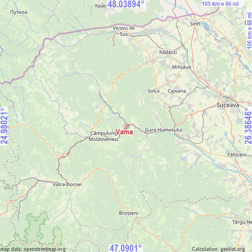
Vama GPS coordinates[2]
47° 34' 0.012" North, 25° 40' 59.988" East
| Map corner | latitude | longitude |
|---|---|---|
| Upper-left | 48.03894°, | 24.98021° |
| Center: | 47.56667°, | 25.68333° |
| Lower-right: | 47.0901°, | 26.38646° |
| Map W x H: | 105.5×105.5 km | = 65.6×65.6mi |
| max Lat: | 48.23793° ⇑7.7% North |
| Vama: | 47.56667° |
| min Lat: | ⇓92.3% South 43.65638° |
| min Long | Vama | max Long |
| 20.31667° | 25.68333° | 29.65403° |
| W 57.3%⇐ | ⇒42.7% E |
Elevation
Elevation of Vama is 649 m = 2129 ft, and this is 394.1 m = 1293 ft above average elevation for this country.
| Max E: |
1278 m = 4193 ft | 4.3% |
| Vama | 649 m 2129 ft | |
| Avg. | 254.9 m = 836 ft | |
Min E: |
-2 m = -7 ft | 95.7% |
See also: Romania elevation on elevation.city.
Geographical zone
Vama is located in North temperate zone (between Tropic of Cancer and the Arctic Circle). Distance of this North polar circle is 2112.3 km =1312.5 mi to North.| Distance of | km | miles | from Vama |
|---|---|---|---|
| North Pole | 4718.1 | 2931.7 | to North |
| Arctic Circle | 2112.3 | 1312.5 | to North |
| Tropic Cancer | 2683 | 1667.1 | to South |
| Equator | 5288.9 | 3286.4 | to South |


Nearby cities:
15 places around Vama: (largest is in red/bold)
• Bucșoaia
10.1 km =6.3 mi,  107°
107°
• Câmpulung Moldovenesc
9.5 km =5.9 mi,  247°
247°
• Deia
5.7 km =3.5 mi,  303°
303°
• Doroteia
11.3 km =7 mi,  130°
130°
• Frasin
9.5 km =5.9 mi, 112°
• Frumosu
6.1 km =3.8 mi,  335°
335°
• Gemenea
12.4 km =7.7 mi,  169°
169°
• Molid
3.8 km =2.4 mi,  88°
88°
• Plutonița
12.5 km =7.8 mi,  139°
139°
• Poiana Micului
12.1 km =7.5 mi,  32°
32°
• Prisaca Dornei
3.3 km =2.1 mi,  215°
215°
• Slătioara
11.8 km =7.3 mi,  187°
187°
• Strâmtura
1.6 km =1 mi,  354°
354°
• Stulpicani
12.8 km =8 mi,  150°
150°
• Vatra Moldoviţei
12.7 km =7.9 mi,  316°
316°
Sources, notices
• [Note1] Compared only with cities in Romania existing in our database
• [Src1] Map data: © OpenStreetMap contributors (CC-BY-SA)
• [Src2] Other city data from geonames.org with taken over terms of usage.
• [Src3] Geographical zone / Annual Mean Temperature by Robert A. Rohde @ Wikipedia
