Slătioara geodata
Slătioara (Suceava) is a populated place; located in Romania in Europe/Bucharest (GMT+3) time zone. With population of 664 people, there are 5787 cities with bigger population in this country. Compared to other cities in Romania, 90.1% of cities are located further ↓South; 57% of cities are located further ←West and 97.7% of cities have lower elevation than Slătioara. Note1


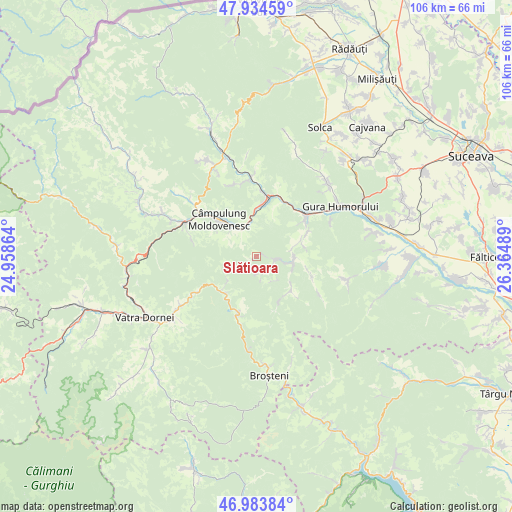
Slătioara GPS coordinates[2]
47° 27' 40.896" North, 25° 39' 42.336" East
| Map corner | latitude | longitude |
|---|---|---|
| Upper-left | 47.93459°, | 24.95864° |
| Center: | 47.46136°, | 25.66176° |
| Lower-right: | 46.98384°, | 26.36489° |
| Map W x H: | 105.7×105.7 km | = 65.7×65.7mi |
| max Lat: | 48.23793° ⇑9.9% North |
| Slătioara: | 47.46136° |
| min Lat: | ⇓90.1% South 43.65638° |
| min Long | Slătioara | max Long |
| 20.31667° | 25.66176° | 29.65403° |
| W 57%⇐ | ⇒43% E |
Elevation
Elevation of Slătioara is 749 m = 2457 ft, and this is 494.1 m = 1621 ft above average elevation for this country.
| Max E: |
1278 m = 4193 ft | 2.3% |
| Slătioara | 749 m 2457 ft | |
| Avg. | 254.9 m = 836 ft | |
Min E: |
-2 m = -7 ft | 97.7% |
See also: Romania elevation on elevation.city.
Geographical zone
Slătioara is located in North temperate zone (between Tropic of Cancer and the Arctic Circle). Distance of this North polar circle is 2124 km =1319.8 mi to North.| Distance of | km | miles | from Slătioara |
|---|---|---|---|
| North Pole | 4729.9 | 2939 | to North |
| Arctic Circle | 2124 | 1319.8 | to North |
| Tropic Cancer | 2671.3 | 1659.9 | to South |
| Equator | 5277.2 | 3279.1 | to South |


Nearby cities:
15 places around Slătioara: (largest is in red/bold)
• Bucșoaia
14.2 km =8.8 mi,  52°
52°
• Crucea
12.8 km =8 mi,  195°
195°
• Câmpulung Moldovenesc
10.7 km =6.6 mi,  318°
318°
• Doroteia
11.1 km =6.9 mi,  67°
67°
• Frasin
13.1 km =8.1 mi, 52°
• Gemenea
3.8 km =2.4 mi,  97°
97°
• Molid
13 km =8.1 mi,  24°
24°
• Negrileasa
12.4 km =7.7 mi,  109°
109°
• Ostra
10.4 km =6.5 mi,  130°
130°
• Plutonița
10 km =6.2 mi,  77°
77°
• Prisaca Dornei
9 km =5.6 mi,  358°
358°
• Sadova
14.6 km =9.1 mi,  303°
303°
• Strâmtura
13.4 km =8.3 mi,  6°
6°
• Stulpicani
7.9 km =4.9 mi,  85°
85°
• Vama
11.8 km =7.3 mi, 7°
Sources, notices
• [Note1] Compared only with cities in Romania existing in our database
• [Src1] Map data: © OpenStreetMap contributors (CC-BY-SA)
• [Src2] Other city data from geonames.org with taken over terms of usage.
• [Src3] Geographical zone / Annual Mean Temperature by Robert A. Rohde @ Wikipedia
