Câmpulung Moldovenesc geodata
Câmpulung Moldovenesc (Suceava) is a seat of a second-order administrative division; located in Romania in Europe/Bucharest (GMT+3) time zone. With population of 19,765 people, there are 108 cities with bigger population in this country. Compared to other cities in Romania, 91.5% of cities are located further ↓South; 55.6% of cities are located further ←West and 95.8% of cities have lower elevation than Câmpulung Moldovenesc. Note1
Current local time in Câmpulung Moldovenesc:
08:17 AM, SaturdayDifference from your time zone: hours


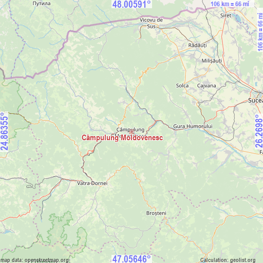
Câmpulung Moldovenesc GPS coordinates[2]
47° 31' 59.988" North, 25° 34' 0.012" East
| Map corner | latitude | longitude |
|---|---|---|
| Upper-left | 48.00591°, | 24.86355° |
| Center: | 47.53333°, | 25.56667° |
| Lower-right: | 47.05646°, | 26.2698° |
| Map W x H: | 105.6×105.6 km | = 65.6×65.6mi |
| max Lat: | 48.23793° ⇑8.5% North |
| Câmpulung Moldovenesc: | 47.53333° |
| min Lat: | ⇓91.5% South 43.65638° |
| min Long | Câmpulung Mold | max Long |
| 20.31667° | 25.56667° | 29.65403° |
| W 55.6%⇐ | ⇒44.4% E |
Elevation
Elevation of Câmpulung Moldovenesc is 655 m = 2149 ft, and this is 400.1 m = 1313 ft above average elevation for this country.
| Max E: |
1278 m = 4193 ft | 4.2% |
| Câmpulung Moldovenesc | 655 m 2149 ft | |
| Avg. | 254.9 m = 836 ft | |
Min E: |
-2 m = -7 ft | 95.8% |
See also: Romania elevation on elevation.city.
Geographical zone
Câmpulung Moldovenesc is located in North temperate zone (between Tropic of Cancer and the Arctic Circle). Distance of this North polar circle is 2116 km =1314.8 mi to North.| Distance of | km | miles | from Câmpulung Moldovenesc |
|---|---|---|---|
| North Pole | 4721.9 | 2934.1 | to North |
| Arctic Circle | 2116 | 1314.8 | to North |
| Tropic Cancer | 2679.3 | 1664.8 | to South |
| Equator | 5285.2 | 3284.1 | to South |


Nearby cities:
15 places around Câmpulung Moldovenesc: (largest is in red/bold)
• Colacu
14.6 km =9.1 mi,  272°
272°
• Deia
7.9 km =4.9 mi,  29°
29°
• Frumosu
11.2 km =7 mi, 34°
• Fundu Moldovei
12.5 km =7.8 mi, 270°
• Gemenea
13.8 km =8.6 mi,  127°
127°
• Moldoviţa
16.9 km =10.5 mi,  351°
351°
• Molid
13.2 km =8.2 mi,  73°
73°
• Pojorâta
9 km =5.6 mi,  258°
258°
• Prisaca Dornei
6.9 km =4.3 mi,  81°
81°
• Sadova
5 km =3.1 mi, 270°
• Slătioara
10.7 km =6.6 mi,  138°
138°
• Strâmtura
10.1 km =6.3 mi,  58°
58°
• Stulpicani
16.8 km =10.4 mi,  116°
116°
• Vama
9.5 km =5.9 mi, 67°
• Vatra Moldoviţei
13 km =8.1 mi,  0°
0°
Sources, notices
• [Note1] Compared only with cities in Romania existing in our database
• [Src1] Map data: © OpenStreetMap contributors (CC-BY-SA)
• [Src2] Other city data from geonames.org with taken over terms of usage.
• [Src3] Geographical zone / Annual Mean Temperature by Robert A. Rohde @ Wikipedia
