Stulpicani geodata
Stulpicani (Suceava) is a seat of a second-order administrative division; located in Romania in Europe/Bucharest (GMT+3) time zone. With population of 6,234 people, there are 504 cities with bigger population in this country. Compared to other cities in Romania, 90.2% of cities are located further ↓South; 58.4% of cities are located further ←West and 93% of cities have lower elevation than Stulpicani. Note1


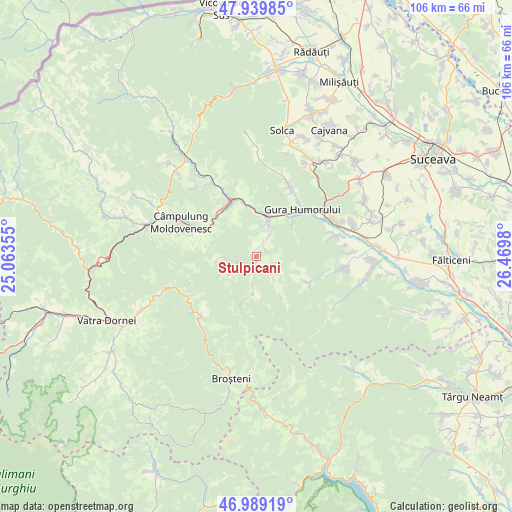
Stulpicani GPS coordinates[2]
47° 28' 0.012" North, 25° 46' 0.012" East
| Map corner | latitude | longitude |
|---|---|---|
| Upper-left | 47.93985°, | 25.06355° |
| Center: | 47.46667°, | 25.76667° |
| Lower-right: | 46.98919°, | 26.4698° |
| Map W x H: | 105.7×105.7 km | = 65.7×65.7mi |
| max Lat: | 48.23793° ⇑9.8% North |
| Stulpicani: | 47.46667° |
| min Lat: | ⇓90.2% South 43.65638° |
| min Long | Stulpicani | max Long |
| 20.31667° | 25.76667° | 29.65403° |
| W 58.4%⇐ | ⇒41.6% E |
Elevation
Elevation of Stulpicani is 570 m = 1870 ft, and this is 315.1 m = 1034 ft above average elevation for this country.
| Max E: |
1278 m = 4193 ft | 7% |
| Stulpicani | 570 m 1870 ft | |
| Avg. | 254.9 m = 836 ft | |
Min E: |
-2 m = -7 ft | 93% |
See also: Romania elevation on elevation.city.
Geographical zone
Stulpicani is located in North temperate zone (between Tropic of Cancer and the Arctic Circle). Distance of this North polar circle is 2123.4 km =1319.4 mi to North.| Distance of | km | miles | from Stulpicani |
|---|---|---|---|
| North Pole | 4729.3 | 2938.6 | to North |
| Arctic Circle | 2123.4 | 1319.4 | to North |
| Tropic Cancer | 2671.9 | 1660.2 | to South |
| Equator | 5277.8 | 3279.5 | to South |


Nearby cities:
15 places around Stulpicani: (largest is in red/bold)
• Bucșoaia
8.8 km =5.5 mi,  22°
22°
• Doroteia
4.4 km =2.7 mi,  32°
32°
• Frasin
7.8 km =4.8 mi, 18°
• Gemenea
4.2 km =2.6 mi,  255°
255°
• Gura Humorului
13.6 km =8.5 mi,  47°
47°
• Găinești
12.5 km =7.8 mi,  114°
114°
• Molid
11.5 km =7.1 mi,  347°
347°
• Negrileasa
6.1 km =3.8 mi,  142°
142°
• Ostra
7.4 km =4.6 mi,  180°
180°
• Plutonița
2.4 km =1.5 mi, 49°
• Prisaca Dornei
11.7 km =7.3 mi,  315°
315°
• Slătioara
7.9 km =4.9 mi,  265°
265°
• Strâmtura
14.2 km =8.8 mi,  333°
333°
• Vadu Negrilesei
10.7 km =6.6 mi,  148°
148°
• Vama
12.8 km =8 mi, 330°
Sources, notices
• [Note1] Compared only with cities in Romania existing in our database
• [Src1] Map data: © OpenStreetMap contributors (CC-BY-SA)
• [Src2] Other city data from geonames.org with taken over terms of usage.
• [Src3] Geographical zone / Annual Mean Temperature by Robert A. Rohde @ Wikipedia
