Valea Largă geodata
Valea Largă (Mureş) is a seat of a second-order administrative division; located in Romania in Europe/Bucharest (GMT+3) time zone. With population of 1,897 people, there are 2709 cities with bigger population in this country. Compared to other cities in Romania, 69.9% of cities are located further ↓South; 68.1% of cities are located further →East and 67.4% of cities have lower elevation than Valea Largă. Note1


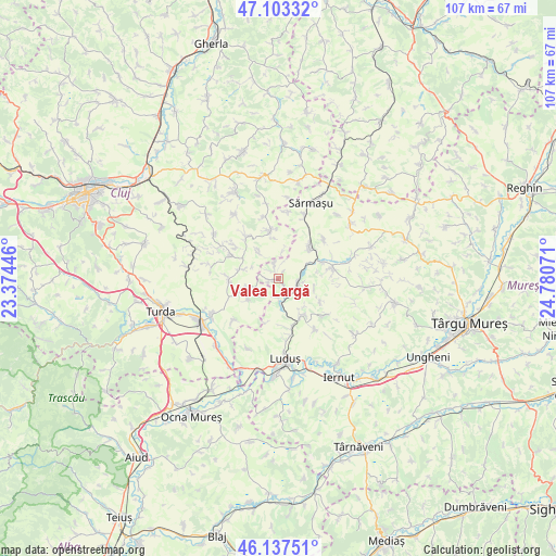
Valea Largă GPS coordinates[2]
46° 37' 21.252" North, 24° 4' 39.288" East
| Map corner | latitude | longitude |
|---|---|---|
| Upper-left | 47.10332°, | 23.37446° |
| Center: | 46.62257°, | 24.07758° |
| Lower-right: | 46.13751°, | 24.78071° |
| Map W x H: | 107.4×107.4 km | = 66.7×66.7mi |
| max Lat: | 48.23793° ⇑30.1% North |
| Valea Largă: | 46.62257° |
| min Lat: | ⇓69.9% South 43.65638° |
| min Long | Valea Largă | max Long |
| 20.31667° | 24.07758° | 29.65403° |
| W 31.9%⇐ | ⇒68.1% E |
Elevation
Elevation of Valea Largă is 304 m = 997 ft, and this is 49.1 m = 161 ft above average elevation for this country.
| Max E: |
1278 m = 4193 ft | 32.6% |
| Valea Largă | 304 m 997 ft | |
| Avg. | 254.9 m = 836 ft | |
Min E: |
-2 m = -7 ft | 67.4% |
See also: Romania elevation on elevation.city.
Geographical zone
Valea Largă is located in North temperate zone (between Tropic of Cancer and the Arctic Circle). Distance of this North polar circle is 2217.2 km =1377.7 mi to North.| Distance of | km | miles | from Valea Largă |
|---|---|---|---|
| North Pole | 4823.1 | 2996.9 | to North |
| Arctic Circle | 2217.2 | 1377.7 | to North |
| Tropic Cancer | 2578 | 1601.9 | to South |
| Equator | 5183.9 | 3221.1 | to South |


Nearby cities:
15 places around Valea Largă: (largest is in red/bold)
• Boian
6.8 km =4.2 mi,  283°
283°
• Bolduț
9.6 km =6 mi,  269°
269°
• Bârza
9.1 km =5.7 mi,  152°
152°
• Colonia
8.5 km =5.3 mi,  250°
250°
• Frata
8.9 km =5.5 mi,  346°
346°
• Iacobeni
6.5 km =4 mi,  324°
324°
• Miheşu de Câmpie
8.7 km =5.4 mi,  39°
39°
• Poduri
1.1 km =0.7 mi,  231°
231°
• Pădureni
5.1 km =3.2 mi, 229°
• Soporu de Câmpie
9.8 km =6.1 mi,  326°
326°
• Sânger
8.5 km =5.3 mi, 147°
• Tritenii de Jos
7.4 km =4.6 mi, 233°
• Tritenii de Sus
6.3 km =3.9 mi, 252°
• Tăureni
4.8 km =3 mi,  177°
177°
• Zau de Câmpie
4.2 km =2.6 mi,  103°
103°
Sources, notices
• [Note1] Compared only with cities in Romania existing in our database
• [Src1] Map data: © OpenStreetMap contributors (CC-BY-SA)
• [Src2] Other city data from geonames.org with taken over terms of usage.
• [Src3] Geographical zone / Annual Mean Temperature by Robert A. Rohde @ Wikipedia
