Iacobeni geodata
Iacobeni (Cluj) is a populated place; located in Romania in Europe/Bucharest (GMT+3) time zone. With population of 783 people, there are 5130 cities with bigger population in this country. Compared to other cities in Romania, 70.9% of cities are located further ↓South; 68.9% of cities are located further →East and 72.2% of cities have lower elevation than Iacobeni. Note1


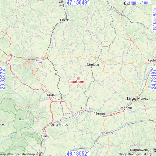
Iacobeni GPS coordinates[2]
46° 40' 12.576" North, 24° 1' 43.824" East
| Map corner | latitude | longitude |
|---|---|---|
| Upper-left | 47.15049°, | 23.32572° |
| Center: | 46.67016°, | 24.02884° |
| Lower-right: | 46.18552°, | 24.73197° |
| Map W x H: | 107.3×107.3 km | = 66.7×66.7mi |
| max Lat: | 48.23793° ⇑29.1% North |
| Iacobeni: | 46.67016° |
| min Lat: | ⇓70.9% South 43.65638° |
| min Long | Iacobeni | max Long |
| 20.31667° | 24.02884° | 29.65403° |
| W 31.1%⇐ | ⇒68.9% E |
Elevation
Elevation of Iacobeni is 335 m = 1099 ft, and this is 80.1 m = 263 ft above average elevation for this country.
| Max E: |
1278 m = 4193 ft | 27.8% |
| Iacobeni | 335 m 1099 ft | |
| Avg. | 254.9 m = 836 ft | |
Min E: |
-2 m = -7 ft | 72.2% |
See also: Romania elevation on elevation.city.
Geographical zone
Iacobeni is located in North temperate zone (between Tropic of Cancer and the Arctic Circle). Distance of this North polar circle is 2211.9 km =1374.4 mi to North.| Distance of | km | miles | from Iacobeni |
|---|---|---|---|
| North Pole | 4817.8 | 2993.6 | to North |
| Arctic Circle | 2211.9 | 1374.4 | to North |
| Tropic Cancer | 2583.3 | 1605.2 | to South |
| Equator | 5189.2 | 3224.4 | to South |


Nearby cities:
15 places around Iacobeni: (largest is in red/bold)
• Berchieșu
6.5 km =4 mi,  6°
6°
• Boian
4.7 km =2.9 mi,  218°
218°
• Bolduț
8 km =5 mi,  227°
227°
• Ceanu Mare
6 km =3.7 mi,  266°
266°
• Colonia
9.2 km =5.7 mi,  208°
208°
• Frata
3.7 km =2.3 mi,  25°
25°
• Miheşu de Câmpie
9.4 km =5.8 mi,  80°
80°
• Poduri
6.6 km =4.1 mi,  154°
154°
• Pădureni
8.6 km =5.3 mi,  180°
180°
• Soporu de Câmpie
3.4 km =2.1 mi,  329°
329°
• Tritenii de Jos
9.9 km =6.2 mi,  192°
192°
• Tritenii de Sus
7.6 km =4.7 mi,  197°
197°
• Valea Largă
6.5 km =4 mi,  144°
144°
• Vișinelu
9.4 km =5.8 mi,  36°
36°
• Zau de Câmpie
10 km =6.2 mi,  128°
128°
Sources, notices
• [Note1] Compared only with cities in Romania existing in our database
• [Src1] Map data: © OpenStreetMap contributors (CC-BY-SA)
• [Src2] Other city data from geonames.org with taken over terms of usage.
• [Src3] Geographical zone / Annual Mean Temperature by Robert A. Rohde @ Wikipedia
