Vaideeni geodata
Vaideeni (Vâlcea) is a seat of a second-order administrative division; located in Romania in Europe/Bucharest (GMT+3) time zone. With population of 4,198 people, there are 1095 cities with bigger population in this country. Compared to other cities in Romania, 63.1% of cities are located further ↑North; 70.7% of cities are located further →East and 91.9% of cities have lower elevation than Vaideeni. Note1


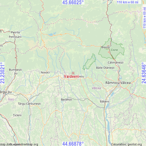
Vaideeni GPS coordinates[2]
45° 10' 0.012" North, 23° 55' 59.988" East
| Map corner | latitude | longitude |
|---|---|---|
| Upper-left | 45.66025°, | 23.23021° |
| Center: | 45.16667°, | 23.93333° |
| Lower-right: | 44.66878°, | 24.63646° |
| Map W x H: | 110.2×110.2 km | = 68.5×68.5mi |
| max Lat: | 48.23793° ⇑63.1% North |
| Vaideeni: | 45.16667° |
| min Lat: | ⇓36.9% South 43.65638° |
| min Long | Vaideeni | max Long |
| 20.31667° | 23.93333° | 29.65403° |
| W 29.3%⇐ | ⇒70.7% E |
Elevation
Elevation of Vaideeni is 546 m = 1791 ft, and this is 291.1 m = 955 ft above average elevation for this country.
| Max E: |
1278 m = 4193 ft | 8.1% |
| Vaideeni | 546 m 1791 ft | |
| Avg. | 254.9 m = 836 ft | |
Min E: |
-2 m = -7 ft | 91.9% |
See also: Romania elevation on elevation.city.
Geographical zone
Vaideeni is located in North temperate zone (between Tropic of Cancer and the Arctic Circle). Distance of this North polar circle is 2379.1 km =1478.3 mi to North.| Distance of | km | miles | from Vaideeni |
|---|---|---|---|
| North Pole | 4985 | 3097.5 | to North |
| Arctic Circle | 2379.1 | 1478.3 | to North |
| Tropic Cancer | 2416.1 | 1501.3 | to South |
| Equator | 5022.1 | 3120.6 | to South |


Nearby cities:
15 places around Vaideeni: (largest is in red/bold)
• Bistrița
8.6 km =5.3 mi,  75°
75°
• Bogdănești
8.6 km =5.3 mi,  111°
111°
• Dianu
9 km =5.6 mi,  175°
175°
• Gorunești
8.2 km =5.1 mi,  203°
203°
• Greci
10.5 km =6.5 mi,  219°
219°
• Horezu
6.8 km =4.2 mi, 105°
• Izvoru Rece
2.6 km =1.6 mi,  271°
271°
• Milostea
8.9 km =5.5 mi,  238°
238°
• Mogești
5.7 km =3.5 mi,  193°
193°
• Măldăreşti
7.6 km =4.7 mi,  136°
136°
• Măldăreștii de Jos
9.3 km =5.8 mi, 135°
• Racovița
7.5 km =4.7 mi, 272°
• Rugetu
5.5 km =3.4 mi, 239°
• Slătioara
5.7 km =3.5 mi, 193°
• Stroeşti
9.6 km =6 mi, 195°
Sources, notices
• [Note1] Compared only with cities in Romania existing in our database
• [Src1] Map data: © OpenStreetMap contributors (CC-BY-SA)
• [Src2] Other city data from geonames.org with taken over terms of usage.
• [Src3] Geographical zone / Annual Mean Temperature by Robert A. Rohde @ Wikipedia
