Racovița geodata
Racovița (Gorj) is a populated place; located in Romania in Europe/Bucharest (GMT+3) time zone. With population of 580 people, there are 6357 cities with bigger population in this country. Compared to other cities in Romania, 62.8% of cities are located further ↑North; 72% of cities are located further →East and 90.8% of cities have lower elevation than Racovița. Note1


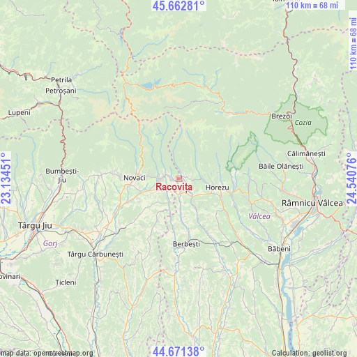
Racovița GPS coordinates[2]
45° 10' 9.3" North, 23° 50' 15.468" East
| Map corner | latitude | longitude |
|---|---|---|
| Upper-left | 45.66281°, | 23.13451° |
| Center: | 45.16925°, | 23.83763° |
| Lower-right: | 44.67138°, | 24.54076° |
| Map W x H: | 110.2×110.2 km | = 68.5×68.5mi |
| max Lat: | 48.23793° ⇑62.8% North |
| Racovița: | 45.16925° |
| min Lat: | ⇓37.2% South 43.65638° |
| min Long | Racovița | max Long |
| 20.31667° | 23.83763° | 29.65403° |
| W 28%⇐ | ⇒72% E |
Elevation
Elevation of Racovița is 526 m = 1726 ft, and this is 271.1 m = 889 ft above average elevation for this country.
| Max E: |
1278 m = 4193 ft | 9.2% |
| Racovița | 526 m 1726 ft | |
| Avg. | 254.9 m = 836 ft | |
Min E: |
-2 m = -7 ft | 90.8% |
See also: Romania elevation on elevation.city.
Geographical zone
Racovița is located in North temperate zone (between Tropic of Cancer and the Arctic Circle). Distance of this North polar circle is 2378.8 km =1478.1 mi to North.| Distance of | km | miles | from Racovița |
|---|---|---|---|
| North Pole | 4984.7 | 3097.3 | to North |
| Arctic Circle | 2378.8 | 1478.1 | to North |
| Tropic Cancer | 2416.4 | 1501.5 | to South |
| Equator | 5022.3 | 3120.7 | to South |


Nearby cities:
15 places around Racovița: (largest is in red/bold)
• Alimpeşti
10 km =6.2 mi,  197°
197°
• Baia de Fier
5.6 km =3.5 mi,  267°
267°
• Cernădia
9.3 km =5.8 mi,  275°
275°
• Gorunești
8.9 km =5.5 mi,  151°
151°
• Greci
8.5 km =5.3 mi,  174°
174°
• Izvoru Rece
4.9 km =3 mi,  92°
92°
• Milostea
4.9 km =3 mi,  181°
181°
• Mogești
8.5 km =5.3 mi,  133°
133°
• Poienari
8.6 km =5.3 mi,  246°
246°
• Polovragi
3.3 km =2.1 mi,  297°
297°
• Rugetu
4.1 km =2.5 mi,  138°
138°
• Slătioara
8.5 km =5.3 mi, 133°
• Stroeşti
10.7 km =6.6 mi, 152°
• Sârbești
7.2 km =4.5 mi,  216°
216°
• Vaideeni
7.5 km =4.7 mi, 92°
Sources, notices
• [Note1] Compared only with cities in Romania existing in our database
• [Src1] Map data: © OpenStreetMap contributors (CC-BY-SA)
• [Src2] Other city data from geonames.org with taken over terms of usage.
• [Src3] Geographical zone / Annual Mean Temperature by Robert A. Rohde @ Wikipedia
