Turulung geodata
Turulung (Satu Mare) is a seat of a second-order administrative division; located in Romania in Europe/Bucharest (GMT+3) time zone. With population of 3,815 people, there are 1256 cities with bigger population in this country. Compared to other cities in Romania, 98.4% of cities are located further ↓South; 83.3% of cities are located further →East and 68.7% of cities have higher elevation than Turulung. Note1


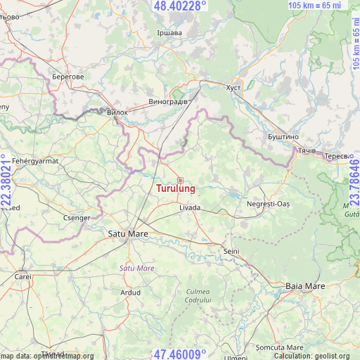
Turulung GPS coordinates[2]
47° 55' 59.988" North, 23° 4' 59.988" East
| Map corner | latitude | longitude |
|---|---|---|
| Upper-left | 48.40228°, | 22.38021° |
| Center: | 47.93333°, | 23.08333° |
| Lower-right: | 47.46009°, | 23.78646° |
| Map W x H: | 104.8×104.8 km | = 65.1×65.1mi |
| max Lat: | 48.23793° ⇑1.6% North |
| Turulung: | 47.93333° |
| min Lat: | ⇓98.4% South 43.65638° |
| min Long | Turulung | max Long |
| 20.31667° | 23.08333° | 29.65403° |
| W 16.7%⇐ | ⇒83.3% E |
Elevation
Elevation of Turulung is 132 m = 433 ft, and this is 122.9 m = 403 ft below average elevation for this country.
| Max E: |
1278 m = 4193 ft | 68.7% |
| Avg. | 254.9 m = 836 ft | |
| Turulung | 132 m = 433 ft | |
Min E: |
-2 m = -7 ft | 31.3% |
See also: Romania elevation on elevation.city.
Geographical zone
Turulung is located in North temperate zone (between Tropic of Cancer and the Arctic Circle). Distance of this North polar circle is 2071.5 km =1287.2 mi to North.| Distance of | km | miles | from Turulung |
|---|---|---|---|
| North Pole | 4677.4 | 2906.4 | to North |
| Arctic Circle | 2071.5 | 1287.2 | to North |
| Tropic Cancer | 2723.8 | 1692.5 | to South |
| Equator | 5329.7 | 3311.7 | to South |


Nearby cities:
15 places around Turulung: (largest is in red/bold)
• Adrian
4.6 km =2.9 mi,  135°
135°
• Agriș
8.3 km =5.2 mi,  225°
225°
• Bătarci
12.7 km =7.9 mi,  29°
29°
• Cidreag
10.7 km =6.6 mi,  303°
303°
• Drăgușeni
3.1 km =1.9 mi,  187°
187°
• Dumbrava
9.9 km =6.2 mi,  181°
181°
• Gherţa Mică
11.2 km =7 mi,  90°
90°
• Gherța Mare
10.1 km =6.3 mi,  67°
67°
• Halmeu
6.2 km =3.9 mi,  306°
306°
• Livada
8.3 km =5.2 mi,  153°
153°
• Micula
10.6 km =6.6 mi,  249°
249°
• Nisipeni
13.8 km =8.6 mi,  255°
255°
• Porumbești
9.4 km =5.8 mi, 305°
• Turţ
11.4 km =7.1 mi,  60°
60°
• Tămășeni
9.9 km =6.2 mi,  23°
23°
Sources, notices
• [Note1] Compared only with cities in Romania existing in our database
• [Src1] Map data: © OpenStreetMap contributors (CC-BY-SA)
• [Src2] Other city data from geonames.org with taken over terms of usage.
• [Src3] Geographical zone / Annual Mean Temperature by Robert A. Rohde @ Wikipedia
