Livada geodata
Livada (Satu Mare) is a seat of a second-order administrative division; located in Romania in Europe/Bucharest (GMT+3) time zone. With population of 6,833 people, there are 422 cities with bigger population in this country. Compared to other cities in Romania, 97.5% of cities are located further ↓South; 82.6% of cities are located further →East and 68.7% of cities have higher elevation than Livada. Note1


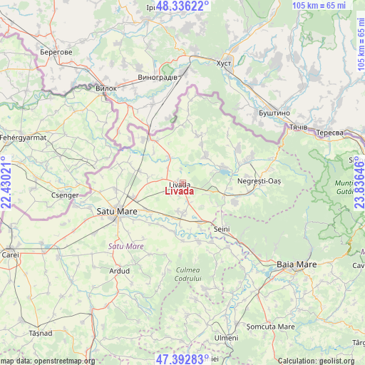
Livada GPS coordinates[2]
47° 52' 0.012" North, 23° 7' 59.988" East
| Map corner | latitude | longitude |
|---|---|---|
| Upper-left | 48.33622°, | 22.43021° |
| Center: | 47.86667°, | 23.13333° |
| Lower-right: | 47.39283°, | 23.83646° |
| Map W x H: | 104.9×104.9 km | = 65.2×65.2mi |
| max Lat: | 48.23793° ⇑2.5% North |
| Livada: | 47.86667° |
| min Lat: | ⇓97.5% South 43.65638° |
| min Long | Livada | max Long |
| 20.31667° | 23.13333° | 29.65403° |
| W 17.4%⇐ | ⇒82.6% E |
Elevation
Elevation of Livada is 132 m = 433 ft, and this is 122.9 m = 403 ft below average elevation for this country.
| Max E: |
1278 m = 4193 ft | 68.7% |
| Avg. | 254.9 m = 836 ft | |
| Livada | 132 m = 433 ft | |
Min E: |
-2 m = -7 ft | 31.3% |
See also: Romania elevation on elevation.city.
Geographical zone
Livada is located in North temperate zone (between Tropic of Cancer and the Arctic Circle). Distance of this North polar circle is 2078.9 km =1291.8 mi to North.| Distance of | km | miles | from Livada |
|---|---|---|---|
| North Pole | 4684.8 | 2911 | to North |
| Arctic Circle | 2078.9 | 1291.8 | to North |
| Tropic Cancer | 2716.4 | 1687.9 | to South |
| Equator | 5322.3 | 3307.1 | to South |


Nearby cities:
15 places around Livada: (largest is in red/bold)
• Adrian
4.1 km =2.5 mi,  353°
353°
• Agriș
9.8 km =6.1 mi,  279°
279°
• Apa
12.2 km =7.6 mi,  155°
155°
• Băbășești
10.4 km =6.5 mi,  194°
194°
• Coca
10.5 km =6.5 mi,  69°
69°
• Drăgușeni
6 km =3.7 mi,  316°
316°
• Dumbrava
4.7 km =2.9 mi,  237°
237°
• Gherţa Mică
10.5 km =6.5 mi,  45°
45°
• Iojib
5.9 km =3.7 mi, 163°
• Medieşu Aurit
9.3 km =5.8 mi,  172°
172°
• Odoreu
12.4 km =7.7 mi,  233°
233°
• Oraşu Nou
11.8 km =7.3 mi,  108°
108°
• Potău
12.3 km =7.6 mi,  184°
184°
• Românești
9.3 km =5.8 mi, 187°
• Turulung
8.3 km =5.2 mi,  333°
333°
Sources, notices
• [Note1] Compared only with cities in Romania existing in our database
• [Src1] Map data: © OpenStreetMap contributors (CC-BY-SA)
• [Src2] Other city data from geonames.org with taken over terms of usage.
• [Src3] Geographical zone / Annual Mean Temperature by Robert A. Rohde @ Wikipedia
