Turnu Măgurele geodata
Turnu Măgurele (Teleorman) is a seat of a second-order administrative division; located in Romania in Europe/Bucharest (GMT+3) time zone. With population of 28,783 people, there are 77 cities with bigger population in this country. Compared to other cities in Romania, 99.8% of cities are located further ↑North; 54.5% of cities are located further →East and 95.9% of cities have higher elevation than Turnu Măgurele. Note1


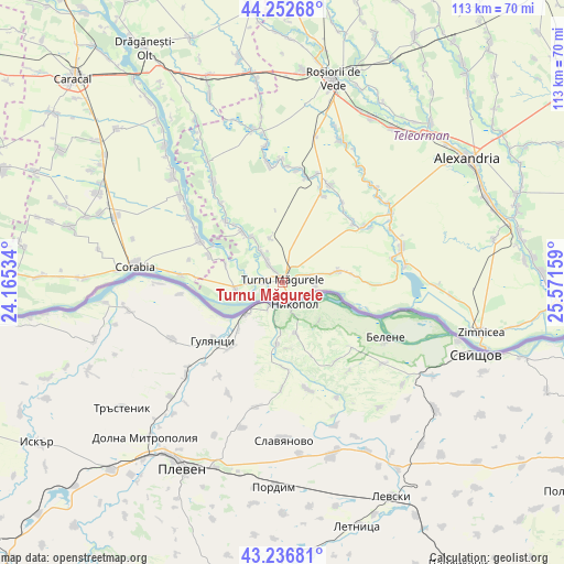
Turnu Măgurele GPS coordinates[2]
43° 44' 48.84" North, 24° 52' 6.456" East
| Map corner | latitude | longitude |
|---|---|---|
| Upper-left | 44.25268°, | 24.16534° |
| Center: | 43.7469°, | 24.86846° |
| Lower-right: | 43.23681°, | 25.57159° |
| Map W x H: | 113×113 km | = 70.2×70.2mi |
| max Lat: | 48.23793° ⇑99.8% North |
| Turnu Măgurele: | 43.7469° |
| min Lat: | ⇓0.2% South 43.65638° |
| min Long | Turnu Măgurele | max Long |
| 20.31667° | 24.86846° | 29.65403° |
| W 45.5%⇐ | ⇒54.5% E |
Elevation
Elevation of Turnu Măgurele is 30 m = 98 ft, and this is 224.9 m = 738 ft below average elevation for this country.
| Max E: |
1278 m = 4193 ft | 95.9% |
| Avg. | 254.9 m = 836 ft | |
| Turnu Măgurele | 30 m = 98 ft | |
Min E: |
-2 m = -7 ft | 4.1% |
See also: Romania elevation on elevation.city.
Geographical zone
Turnu Măgurele is located in North temperate zone (between Tropic of Cancer and the Arctic Circle). Distance of this Northern Tropic circle is 2258.3 km =1403.2 mi to South.| Distance of | km | miles | from Turnu Măgurele |
|---|---|---|---|
| North Pole | 5142.9 | 3195.6 | to North |
| Arctic Circle | 2537 | 1576.4 | to North |
| Tropic Cancer | 2258.3 | 1403.2 | to South |
| Equator | 4864.2 | 3022.5 | to South |


Nearby cities:
15 places around Turnu Măgurele: (largest is in red/bold)
• Ciuperceni
6.9 km =4.3 mi,  71°
71°
• Giuvărăşti
14.8 km =9.2 mi,  293°
293°
• Islaz
8.9 km =5.5 mi,  250°
250°
• Liţa
7.2 km =4.5 mi,  324°
324°
• Lunca
12.6 km =7.8 mi, 319°
• Moldoveni
11.8 km =7.3 mi, 286°
• Olteanca
11 km =6.8 mi,  327°
327°
• Pleașov
14.9 km =9.3 mi, 319°
• Poiana
6.8 km =4.2 mi,  94°
94°
• Prundu
16.6 km =10.3 mi,  301°
301°
• Saelele
16.5 km =10.3 mi, 317°
• Seaca
15.9 km =9.9 mi, 88°
• Segarcea Vale
9.5 km =5.9 mi, 324°
• Segarcea-Deal
9 km =5.6 mi,  345°
345°
• Traian
10.8 km =6.7 mi,  78°
78°
Sources, notices
• [Note1] Compared only with cities in Romania existing in our database
• [Src1] Map data: © OpenStreetMap contributors (CC-BY-SA)
• [Src2] Other city data from geonames.org with taken over terms of usage.
• [Src3] Geographical zone / Annual Mean Temperature by Robert A. Rohde @ Wikipedia
