Liţa geodata
Liţa (Teleorman) is a seat of a second-order administrative division; located in Romania in Europe/Bucharest (GMT+3) time zone. With population of 3,166 people, there are 1644 cities with bigger population in this country. Compared to other cities in Romania, 99.5% of cities are located further ↑North; 55.2% of cities are located further →East and 90.2% of cities have higher elevation than Liţa. Note1


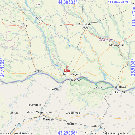
Liţa GPS coordinates[2]
43° 48' 0" North, 24° 49' 0.012" East
| Map corner | latitude | longitude |
|---|---|---|
| Upper-left | 44.30533°, | 24.11355° |
| Center: | 43.8°, | 24.81667° |
| Lower-right: | 43.29036°, | 25.5198° |
| Map W x H: | 112.9×112.9 km | = 70.2×70.2mi |
| max Lat: | 48.23793° ⇑99.5% North |
| Liţa: | 43.8° |
| min Lat: | ⇓0.5% South 43.65638° |
| min Long | Liţa | max Long |
| 20.31667° | 24.81667° | 29.65403° |
| W 44.8%⇐ | ⇒55.2% E |
Elevation
Elevation of Liţa is 57 m = 187 ft, and this is 197.9 m = 649 ft below average elevation for this country.
| Max E: |
1278 m = 4193 ft | 90.2% |
| Avg. | 254.9 m = 836 ft | |
| Liţa | 57 m = 187 ft | |
Min E: |
-2 m = -7 ft | 9.8% |
See also: Romania elevation on elevation.city.
Geographical zone
Liţa is located in North temperate zone (between Tropic of Cancer and the Arctic Circle). Distance of this Northern Tropic circle is 2264.2 km =1406.9 mi to South.| Distance of | km | miles | from Liţa |
|---|---|---|---|
| North Pole | 5137 | 3192 | to North |
| Arctic Circle | 2531.1 | 1572.8 | to North |
| Tropic Cancer | 2264.2 | 1406.9 | to South |
| Equator | 4870.1 | 3026.1 | to South |


Nearby cities:
15 places around Liţa: (largest is in red/bold)
• Ciuperceni
11.3 km =7 mi,  109°
109°
• Giuvărăşti
9.4 km =5.8 mi,  270°
270°
• Islaz
9.8 km =6.1 mi,  205°
205°
• Lunca
5.5 km =3.4 mi,  312°
312°
• Moldoveni
7.5 km =4.7 mi,  250°
250°
• Olteanca
3.8 km =2.4 mi,  333°
333°
• Pleașov
7.8 km =4.8 mi,  315°
315°
• Poiana
12.7 km =7.9 mi,  120°
120°
• Prundu
10.4 km =6.5 mi,  284°
284°
• Saelele
9.4 km =5.8 mi, 311°
• Segarcea Vale
2.3 km =1.4 mi, 324°
• Segarcea-Deal
3.4 km =2.1 mi,  33°
33°
• Turnu Măgurele
7.2 km =4.5 mi,  144°
144°
• Uda-Clocociov
12.8 km =8 mi, 319°
• Uda-Paciurea
11.6 km =7.2 mi, 319°
Sources, notices
• [Note1] Compared only with cities in Romania existing in our database
• [Src1] Map data: © OpenStreetMap contributors (CC-BY-SA)
• [Src2] Other city data from geonames.org with taken over terms of usage.
• [Src3] Geographical zone / Annual Mean Temperature by Robert A. Rohde @ Wikipedia
