Prundu geodata
Prundu (Teleorman) is a populated place; located in Romania in Europe/Bucharest (GMT+3) time zone. With population of 1,060 people, there are 4091 cities with bigger population in this country. Compared to other cities in Romania, 99.2% of cities are located further ↑North; 57.4% of cities are located further →East and 94.7% of cities have higher elevation than Prundu. Note1


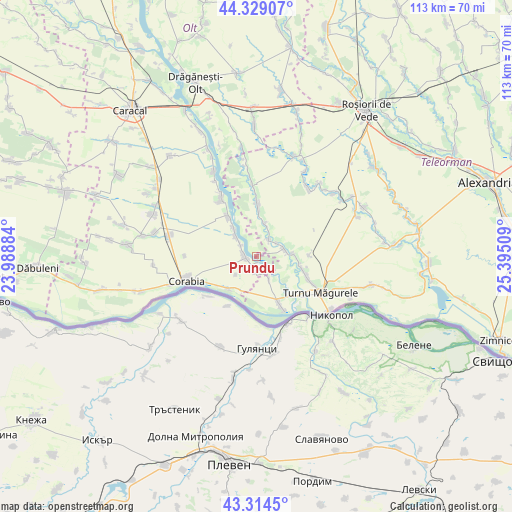
Prundu GPS coordinates[2]
43° 49' 26.184" North, 24° 41' 31.056" East
| Map corner | latitude | longitude |
|---|---|---|
| Upper-left | 44.32907°, | 23.98884° |
| Center: | 43.82394°, | 24.69196° |
| Lower-right: | 43.3145°, | 25.39509° |
| Map W x H: | 112.8×112.8 km | = 70.1×70.1mi |
| max Lat: | 48.23793° ⇑99.2% North |
| Prundu: | 43.82394° |
| min Lat: | ⇓0.8% South 43.65638° |
| min Long | Prundu | max Long |
| 20.31667° | 24.69196° | 29.65403° |
| W 42.6%⇐ | ⇒57.4% E |
Elevation
Elevation of Prundu is 36 m = 118 ft, and this is 218.9 m = 718 ft below average elevation for this country.
| Max E: |
1278 m = 4193 ft | 94.7% |
| Avg. | 254.9 m = 836 ft | |
| Prundu | 36 m = 118 ft | |
Min E: |
-2 m = -7 ft | 5.3% |
See also: Romania elevation on elevation.city.
Geographical zone
Prundu is located in North temperate zone (between Tropic of Cancer and the Arctic Circle). Distance of this Northern Tropic circle is 2266.8 km =1408.5 mi to South.| Distance of | km | miles | from Prundu |
|---|---|---|---|
| North Pole | 5134.3 | 3190.3 | to North |
| Arctic Circle | 2528.4 | 1571.1 | to North |
| Tropic Cancer | 2266.8 | 1408.5 | to South |
| Equator | 4872.8 | 3027.8 | to South |


Nearby cities:
15 places around Prundu: (largest is in red/bold)
• Doanca
4.4 km =2.7 mi,  308°
308°
• Giuvărăşti
2.7 km =1.7 mi,  166°
166°
• Gârcov
9.5 km =5.9 mi,  220°
220°
• Izbiceni
3.5 km =2.2 mi,  287°
287°
• Lunca
6.1 km =3.8 mi,  80°
80°
• Moldoveni
5.9 km =3.7 mi,  150°
150°
• Olteanca
8.4 km =5.2 mi,  85°
85°
• Pleașov
5.4 km =3.4 mi,  57°
57°
• Potlogeni
7.9 km =4.9 mi,  321°
321°
• Saelele
4.6 km =2.9 mi,  39°
39°
• Segarcea Vale
8.7 km =5.4 mi,  95°
95°
• Tia Mare
6.7 km =4.2 mi, 315°
• Uda-Clocociov
7.3 km =4.5 mi,  14°
14°
• Uda-Paciurea
6.7 km =4.2 mi,  22°
22°
• Ursa
5.9 km =3.7 mi,  227°
227°
Sources, notices
• [Note1] Compared only with cities in Romania existing in our database
• [Src1] Map data: © OpenStreetMap contributors (CC-BY-SA)
• [Src2] Other city data from geonames.org with taken over terms of usage.
• [Src3] Geographical zone / Annual Mean Temperature by Robert A. Rohde @ Wikipedia
