Olteanca geodata
Olteanca (Teleorman) is a populated place; located in Romania in Europe/Bucharest (GMT+3) time zone. With population of 1,209 people, there are 3721 cities with bigger population in this country. Compared to other cities in Romania, 99.2% of cities are located further ↑North; 55.5% of cities are located further →East and 91.3% of cities have higher elevation than Olteanca. Note1


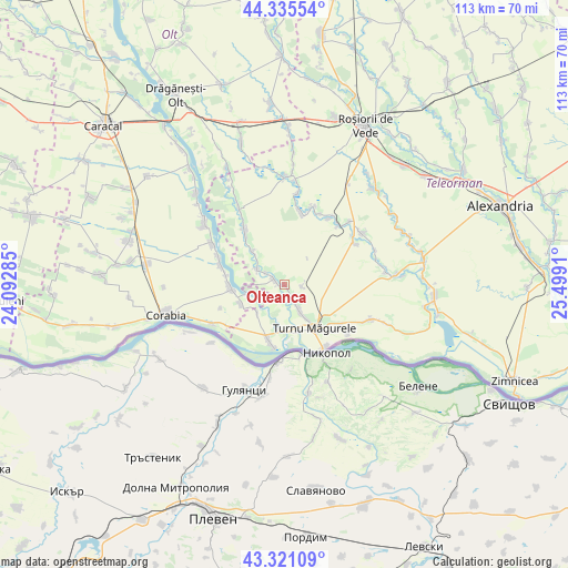
Olteanca GPS coordinates[2]
43° 49' 49.692" North, 24° 47' 45.492" East
| Map corner | latitude | longitude |
|---|---|---|
| Upper-left | 44.33554°, | 24.09285° |
| Center: | 43.83047°, | 24.79597° |
| Lower-right: | 43.32109°, | 25.4991° |
| Map W x H: | 112.8×112.8 km | = 70.1×70.1mi |
| max Lat: | 48.23793° ⇑99.2% North |
| Olteanca: | 43.83047° |
| min Lat: | ⇓0.8% South 43.65638° |
| min Long | Olteanca | max Long |
| 20.31667° | 24.79597° | 29.65403° |
| W 44.5%⇐ | ⇒55.5% E |
Elevation
Elevation of Olteanca is 52 m = 171 ft, and this is 202.9 m = 666 ft below average elevation for this country.
| Max E: |
1278 m = 4193 ft | 91.3% |
| Avg. | 254.9 m = 836 ft | |
| Olteanca | 52 m = 171 ft | |
Min E: |
-2 m = -7 ft | 8.7% |
See also: Romania elevation on elevation.city.
Geographical zone
Olteanca is located in North temperate zone (between Tropic of Cancer and the Arctic Circle). Distance of this Northern Tropic circle is 2267.6 km =1409 mi to South.| Distance of | km | miles | from Olteanca |
|---|---|---|---|
| North Pole | 5133.6 | 3189.9 | to North |
| Arctic Circle | 2527.7 | 1570.6 | to North |
| Tropic Cancer | 2267.6 | 1409 | to South |
| Equator | 4873.5 | 3028.3 | to South |


Nearby cities:
15 places around Olteanca: (largest is in red/bold)
• Doanca
11.9 km =7.4 mi,  279°
279°
• Giuvărăşti
8.4 km =5.2 mi,  246°
246°
• Izbiceni
11.7 km =7.3 mi,  271°
271°
• Liţa
3.8 km =2.4 mi,  153°
153°
• Lunca
2.4 km =1.5 mi, 277°
• Moldoveni
8 km =5 mi,  222°
222°
• Pleașov
4.3 km =2.7 mi,  299°
299°
• Prundu
8.4 km =5.2 mi, 265°
• Saelele
6.1 km =3.8 mi, 297°
• Segarcea Vale
1.6 km =1 mi,  168°
168°
• Segarcea-Deal
3.6 km =2.2 mi,  98°
98°
• Slobozia-Mândra
12.3 km =7.6 mi,  321°
321°
• Turnu Măgurele
11 km =6.8 mi, 147°
• Uda-Clocociov
9.1 km =5.7 mi,  314°
314°
• Uda-Paciurea
8 km =5 mi, 313°
Sources, notices
• [Note1] Compared only with cities in Romania existing in our database
• [Src1] Map data: © OpenStreetMap contributors (CC-BY-SA)
• [Src2] Other city data from geonames.org with taken over terms of usage.
• [Src3] Geographical zone / Annual Mean Temperature by Robert A. Rohde @ Wikipedia
