Toporu geodata
Toporu (Giurgiu) is a seat of a second-order administrative division; located in Romania in Europe/Bucharest (GMT+3) time zone. With population of 2,536 people, there are 2127 cities with bigger population in this country. Compared to other cities in Romania, 96.8% of cities are located further ↑North; 56.9% of cities are located further ←West and 82.2% of cities have higher elevation than Toporu. Note1


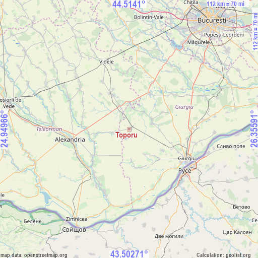
Toporu GPS coordinates[2]
44° 0' 38.016" North, 25° 39' 10.008" East
| Map corner | latitude | longitude |
|---|---|---|
| Upper-left | 44.5141°, | 24.94966° |
| Center: | 44.01056°, | 25.65278° |
| Lower-right: | 43.50271°, | 26.35591° |
| Map W x H: | 112.5×112.5 km | = 69.9×69.9mi |
| max Lat: | 48.23793° ⇑96.8% North |
| Toporu: | 44.01056° |
| min Lat: | ⇓3.2% South 43.65638° |
| min Long | Toporu | max Long |
| 20.31667° | 25.65278° | 29.65403° |
| W 56.9%⇐ | ⇒43.1% E |
Elevation
Elevation of Toporu is 87 m = 285 ft, and this is 167.9 m = 551 ft below average elevation for this country.
| Max E: |
1278 m = 4193 ft | 82.2% |
| Avg. | 254.9 m = 836 ft | |
| Toporu | 87 m = 285 ft | |
Min E: |
-2 m = -7 ft | 17.8% |
See also: Romania elevation on elevation.city.
Geographical zone
Toporu is located in North temperate zone (between Tropic of Cancer and the Arctic Circle). Distance of this Northern Tropic circle is 2287.6 km =1421.4 mi to South.| Distance of | km | miles | from Toporu |
|---|---|---|---|
| North Pole | 5113.5 | 3177.4 | to North |
| Arctic Circle | 2507.7 | 1558.2 | to North |
| Tropic Cancer | 2287.6 | 1421.4 | to South |
| Equator | 4893.5 | 3040.7 | to South |


Nearby cities:
15 places around Toporu: (largest is in red/bold)
• Bujoreni
11.9 km =7.4 mi,  352°
352°
• Chiriacu
10.9 km =6.8 mi,  66°
66°
• Comoara
16.3 km =10.1 mi,  314°
314°
• Cucuruzu
10 km =6.2 mi,  39°
39°
• Drăgăneşti-Vlaşca
11 km =6.8 mi,  336°
336°
• Izvoarele
10.1 km =6.3 mi,  75°
75°
• Izvoru
14 km =8.7 mi,  176°
176°
• Prunaru
12.8 km =8 mi,  9°
9°
• Putineiu
13.9 km =8.6 mi,  152°
152°
• Răsmireşti
8.8 km =5.5 mi,  249°
249°
• Răsuceni
9.1 km =5.7 mi, 5°
• Schitu Poienari
14.2 km =8.8 mi,  260°
260°
• Siliștea
14.9 km =9.3 mi,  265°
265°
• Tomulești
3.9 km =2.4 mi,  198°
198°
• Valea Bujorului
16.2 km =10.1 mi,  62°
62°
Sources, notices
• [Note1] Compared only with cities in Romania existing in our database
• [Src1] Map data: © OpenStreetMap contributors (CC-BY-SA)
• [Src2] Other city data from geonames.org with taken over terms of usage.
• [Src3] Geographical zone / Annual Mean Temperature by Robert A. Rohde @ Wikipedia
