Tinca geodata
Tinca (Bihor) is a seat of a second-order administrative division; located in Romania in Europe/Bucharest (GMT+3) time zone. With population of 4,494 people, there are 955 cities with bigger population in this country. Compared to other cities in Romania, 73.5% of cities are located further ↓South; 95% of cities are located further →East and 69.8% of cities have higher elevation than Tinca. Note1


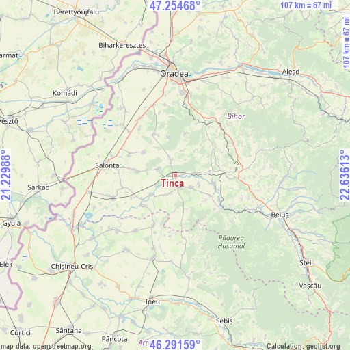
Tinca GPS coordinates[2]
46° 46' 31.044" North, 21° 55' 58.8" East
| Map corner | latitude | longitude |
|---|---|---|
| Upper-left | 47.25468°, | 21.22988° |
| Center: | 46.77529°, | 21.933° |
| Lower-right: | 46.29159°, | 22.63613° |
| Map W x H: | 107.1×107.1 km | = 66.5×66.5mi |
| max Lat: | 48.23793° ⇑26.5% North |
| Tinca: | 46.77529° |
| min Lat: | ⇓73.5% South 43.65638° |
| min Long | Tinca | max Long |
| 20.31667° | 21.933° | 29.65403° |
| W 5%⇐ | ⇒95% E |
Elevation
Elevation of Tinca is 128 m = 420 ft, and this is 126.9 m = 416 ft below average elevation for this country.
| Max E: |
1278 m = 4193 ft | 69.8% |
| Avg. | 254.9 m = 836 ft | |
| Tinca | 128 m = 420 ft | |
Min E: |
-2 m = -7 ft | 30.2% |
See also: Romania elevation on elevation.city.
Geographical zone
Tinca is located in North temperate zone (between Tropic of Cancer and the Arctic Circle). Distance of this North polar circle is 2200.2 km =1367.1 mi to North.| Distance of | km | miles | from Tinca |
|---|---|---|---|
| North Pole | 4806.1 | 2986.4 | to North |
| Arctic Circle | 2200.2 | 1367.1 | to North |
| Tropic Cancer | 2595 | 1612.5 | to South |
| Equator | 5200.9 | 3231.7 | to South |


Nearby cities:
15 places around Tinca: (largest is in red/bold)
• Belfir
4.4 km =2.7 mi,  163°
163°
• Cheșa
7.6 km =4.7 mi,  110°
110°
• Cociuba Mare
6.9 km =4.3 mi,  132°
132°
• Călacea
10.9 km =6.8 mi,  180°
180°
• Căuașd
8.8 km =5.5 mi,  281°
281°
• Dumbrava
10.5 km =6.5 mi,  83°
83°
• Gepiș
10.3 km =6.4 mi,  40°
40°
• Gurbediu
5.6 km =3.5 mi,  291°
291°
• Husasău de Tinca
4.8 km =3 mi,  344°
344°
• Ianoșda
11.8 km =7.3 mi,  306°
306°
• Olcea
10.9 km =6.8 mi, 159°
• Râpa
7 km =4.3 mi, 83°
• Sititelec
11.5 km =7.1 mi,  348°
348°
• Tulca
11.4 km =7.1 mi,  274°
274°
• Tăut
9.5 km =5.9 mi,  229°
229°
Sources, notices
• [Note1] Compared only with cities in Romania existing in our database
• [Src1] Map data: © OpenStreetMap contributors (CC-BY-SA)
• [Src2] Other city data from geonames.org with taken over terms of usage.
• [Src3] Geographical zone / Annual Mean Temperature by Robert A. Rohde @ Wikipedia
