Sititelec geodata
Sititelec (Bihor) is a populated place; located in Romania in Europe/Bucharest (GMT+3) time zone. With population of 561 people, there are 6492 cities with bigger population in this country. Compared to other cities in Romania, 75.9% of cities are located further ↓South; 95.1% of cities are located further →East and 58.7% of cities have higher elevation than Sititelec. Note1


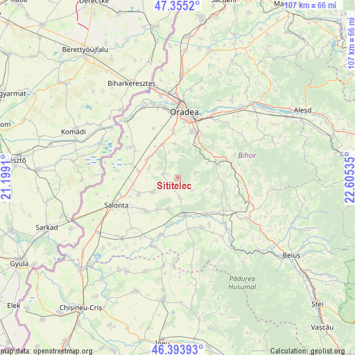
Sititelec GPS coordinates[2]
46° 52' 36.192" North, 21° 54' 7.992" East
| Map corner | latitude | longitude |
|---|---|---|
| Upper-left | 47.3552°, | 21.1991° |
| Center: | 46.87672°, | 21.90222° |
| Lower-right: | 46.39393°, | 22.60535° |
| Map W x H: | 106.9×106.9 km | = 66.4×66.4mi |
| max Lat: | 48.23793° ⇑24.1% North |
| Sititelec: | 46.87672° |
| min Lat: | ⇓75.9% South 43.65638° |
| min Long | Sititelec | max Long |
| 20.31667° | 21.90222° | 29.65403° |
| W 4.9%⇐ | ⇒95.1% E |
Elevation
Elevation of Sititelec is 171 m = 561 ft, and this is 83.9 m = 275 ft below average elevation for this country.
| Max E: |
1278 m = 4193 ft | 58.7% |
| Avg. | 254.9 m = 836 ft | |
| Sititelec | 171 m = 561 ft | |
Min E: |
-2 m = -7 ft | 41.3% |
See also: Romania elevation on elevation.city.
Geographical zone
Sititelec is located in North temperate zone (between Tropic of Cancer and the Arctic Circle). Distance of this North polar circle is 2189 km =1360.2 mi to North.| Distance of | km | miles | from Sititelec |
|---|---|---|---|
| North Pole | 4794.9 | 2979.4 | to North |
| Arctic Circle | 2189 | 1360.2 | to North |
| Tropic Cancer | 2606.3 | 1619.5 | to South |
| Equator | 5212.2 | 3238.7 | to South |


Nearby cities:
15 places around Sititelec: (largest is in red/bold)
• Bicaci
9.1 km =5.7 mi,  287°
287°
• Cordău
10.2 km =6.3 mi,  37°
37°
• Căuașd
11.4 km =7.1 mi,  213°
213°
• Gepiu
10.4 km =6.5 mi,  305°
305°
• Gepiș
9.6 km =6 mi,  110°
110°
• Gurbediu
9.7 km =6 mi,  197°
197°
• Homorog
13 km =8.1 mi,  246°
246°
• Husasău de Tinca
6.8 km =4.2 mi,  170°
170°
• Ianoșda
8.4 km =5.2 mi,  238°
238°
• Inand
11.7 km =7.3 mi,  279°
279°
• Leș
10.9 km =6.8 mi,  334°
334°
• Lăzăreni
12.6 km =7.8 mi,  95°
95°
• Mierlău
9.6 km =6 mi,  63°
63°
• Nojorid
11.9 km =7.4 mi,  353°
353°
• Tinca
11.5 km =7.1 mi, 168°
Sources, notices
• [Note1] Compared only with cities in Romania existing in our database
• [Src1] Map data: © OpenStreetMap contributors (CC-BY-SA)
• [Src2] Other city data from geonames.org with taken over terms of usage.
• [Src3] Geographical zone / Annual Mean Temperature by Robert A. Rohde @ Wikipedia
