Husasău de Tinca geodata
Husasău de Tinca (Bihor) is a seat of a second-order administrative division; located in Romania in Europe/Bucharest (GMT+3) time zone. With population of 2,324 people, there are 2299 cities with bigger population in this country. Compared to other cities in Romania, 74.5% of cities are located further ↓South; 95.1% of cities are located further →East and 68.4% of cities have higher elevation than Husasău de Tinca. Note1


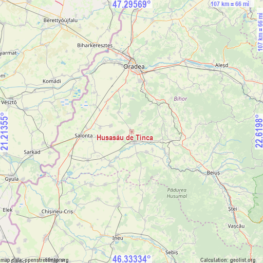
Husasău de Tinca GPS coordinates[2]
46° 49' 0.012" North, 21° 55' 0.012" East
| Map corner | latitude | longitude |
|---|---|---|
| Upper-left | 47.29569°, | 21.21355° |
| Center: | 46.81667°, | 21.91667° |
| Lower-right: | 46.33334°, | 22.6198° |
| Map W x H: | 107×107 km | = 66.5×66.5mi |
| max Lat: | 48.23793° ⇑25.5% North |
| Husasău de Tinca: | 46.81667° |
| min Lat: | ⇓74.5% South 43.65638° |
| min Long | Husasău de Tin | max Long |
| 20.31667° | 21.91667° | 29.65403° |
| W 4.9%⇐ | ⇒95.1% E |
Elevation
Elevation of Husasău de Tinca is 133 m = 436 ft, and this is 121.9 m = 400 ft below average elevation for this country.
| Max E: |
1278 m = 4193 ft | 68.4% |
| Avg. | 254.9 m = 836 ft | |
| Husasău de Tinca | 133 m = 436 ft | |
Min E: |
-2 m = -7 ft | 31.6% |
See also: Romania elevation on elevation.city.
Geographical zone
Husasău de Tinca is located in North temperate zone (between Tropic of Cancer and the Arctic Circle). Distance of this North polar circle is 2195.6 km =1364.3 mi to North.| Distance of | km | miles | from Husasău de Tinca |
|---|---|---|---|
| North Pole | 4801.5 | 2983.5 | to North |
| Arctic Circle | 2195.6 | 1364.3 | to North |
| Tropic Cancer | 2599.6 | 1615.3 | to South |
| Equator | 5205.5 | 3234.5 | to South |


Nearby cities:
15 places around Husasău de Tinca: (largest is in red/bold)
• Belfir
9.2 km =5.7 mi,  164°
164°
• Cheșa
11.1 km =6.9 mi,  131°
131°
• Cociuba Mare
11.2 km =7 mi,  145°
145°
• Căuașd
7.9 km =4.9 mi,  248°
248°
• Dumbrava
12.2 km =7.6 mi,  106°
106°
• Gepiș
8.5 km =5.3 mi,  67°
67°
• Gurbediu
4.7 km =2.9 mi,  237°
237°
• Homorog
13.1 km =8.1 mi,  276°
276°
• Ianoșda
8.6 km =5.3 mi,  285°
285°
• Lăzăreni
12.7 km =7.9 mi,  64°
64°
• Râpa
9 km =5.6 mi, 114°
• Sititelec
6.8 km =4.2 mi,  350°
350°
• Tinca
4.8 km =3 mi, 164°
• Tulca
10.8 km =6.7 mi, 249°
• Tăut
12.3 km =7.6 mi,  208°
208°
Sources, notices
• [Note1] Compared only with cities in Romania existing in our database
• [Src1] Map data: © OpenStreetMap contributors (CC-BY-SA)
• [Src2] Other city data from geonames.org with taken over terms of usage.
• [Src3] Geographical zone / Annual Mean Temperature by Robert A. Rohde @ Wikipedia
