Tătărăi geodata
Tătărăi (Prahova) is a populated place; located in Romania in Europe/Bucharest (GMT+3) time zone. With population of 814 people, there are 4973 cities with bigger population in this country. Compared to other cities in Romania, 78.7% of cities are located further ↑North; 61.5% of cities are located further ←West and 70.9% of cities have higher elevation than Tătărăi. Note1


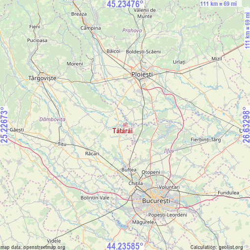
Tătărăi GPS coordinates[2]
44° 44' 14.856" North, 25° 55' 47.46" East
| Map corner | latitude | longitude |
|---|---|---|
| Upper-left | 45.23476°, | 25.22673° |
| Center: | 44.73746°, | 25.92985° |
| Lower-right: | 44.23585°, | 26.63298° |
| Map W x H: | 111.1×111.1 km | = 69×69mi |
| max Lat: | 48.23793° ⇑78.7% North |
| Tătărăi: | 44.73746° |
| min Lat: | ⇓21.3% South 43.65638° |
| min Long | Tătărăi | max Long |
| 20.31667° | 25.92985° | 29.65403° |
| W 61.5%⇐ | ⇒38.5% E |
Elevation
Elevation of Tătărăi is 124 m = 407 ft, and this is 130.9 m = 429 ft below average elevation for this country.
| Max E: |
1278 m = 4193 ft | 70.9% |
| Avg. | 254.9 m = 836 ft | |
| Tătărăi | 124 m = 407 ft | |
Min E: |
-2 m = -7 ft | 29.1% |
See also: Romania elevation on elevation.city.
Geographical zone
Tătărăi is located in North temperate zone (between Tropic of Cancer and the Arctic Circle). Distance of this Northern Tropic circle is 2368.4 km =1471.7 mi to South.| Distance of | km | miles | from Tătărăi |
|---|---|---|---|
| North Pole | 5032.7 | 3127.2 | to North |
| Arctic Circle | 2426.8 | 1507.9 | to North |
| Tropic Cancer | 2368.4 | 1471.7 | to South |
| Equator | 4974.3 | 3090.9 | to South |


Nearby cities:
15 places around Tătărăi: (largest is in red/bold)
• Bujoreanca
3.1 km =1.9 mi,  256°
256°
• Buriaș
4 km =2.5 mi,  96°
96°
• Butimanu
6.5 km =4 mi,  201°
201°
• Ciocănari
5.8 km =3.6 mi,  139°
139°
• Cojasca
6.7 km =4.2 mi,  249°
249°
• Corneşti
7.1 km =4.4 mi,  315°
315°
• Cătunu
3.3 km =2.1 mi,  278°
278°
• Fântânele
5.5 km =3.4 mi, 245°
• Hăbud
4.4 km =2.7 mi,  2°
2°
• Niculești
6.2 km =3.9 mi,  170°
170°
• Ologeni
1.7 km =1.1 mi, 104°
• Poienarii Burchii
7 km =4.3 mi,  78°
78°
• Tăriceni
7.2 km =4.5 mi,  25°
25°
• Ungureni
5.8 km =3.6 mi,  335°
335°
• Şirna
7.1 km =4.4 mi,  12°
12°
Sources, notices
• [Note1] Compared only with cities in Romania existing in our database
• [Src1] Map data: © OpenStreetMap contributors (CC-BY-SA)
• [Src2] Other city data from geonames.org with taken over terms of usage.
• [Src3] Geographical zone / Annual Mean Temperature by Robert A. Rohde @ Wikipedia
