Butimanu geodata
Butimanu (Dâmboviţa) is a seat of a second-order administrative division; located in Romania in Europe/Bucharest (GMT+3) time zone. With population of 2,335 people, there are 2285 cities with bigger population in this country. Compared to other cities in Romania, 80.6% of cities are located further ↑North; 61% of cities are located further ←West and 71.6% of cities have higher elevation than Butimanu. Note1


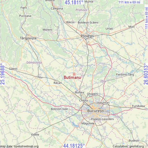
Butimanu GPS coordinates[2]
44° 40' 59.988" North, 25° 54' 0" East
| Map corner | latitude | longitude |
|---|---|---|
| Upper-left | 45.1811°, | 25.19688° |
| Center: | 44.68333°, | 25.9° |
| Lower-right: | 44.18125°, | 26.60313° |
| Map W x H: | 111.2×111.2 km | = 69.1×69.1mi |
| max Lat: | 48.23793° ⇑80.6% North |
| Butimanu: | 44.68333° |
| min Lat: | ⇓19.4% South 43.65638° |
| min Long | Butimanu | max Long |
| 20.31667° | 25.9° | 29.65403° |
| W 61%⇐ | ⇒39% E |
Elevation
Elevation of Butimanu is 121 m = 397 ft, and this is 133.9 m = 439 ft below average elevation for this country.
| Max E: |
1278 m = 4193 ft | 71.6% |
| Avg. | 254.9 m = 836 ft | |
| Butimanu | 121 m = 397 ft | |
Min E: |
-2 m = -7 ft | 28.4% |
See also: Romania elevation on elevation.city.
Geographical zone
Butimanu is located in North temperate zone (between Tropic of Cancer and the Arctic Circle). Distance of this Northern Tropic circle is 2362.4 km =1467.9 mi to South.| Distance of | km | miles | from Butimanu |
|---|---|---|---|
| North Pole | 5038.7 | 3130.9 | to North |
| Arctic Circle | 2432.9 | 1511.7 | to North |
| Tropic Cancer | 2362.4 | 1467.9 | to South |
| Equator | 4968.3 | 3087.2 | to South |


Nearby cities:
15 places around Butimanu: (largest is in red/bold)
• Bujoreanca
5.3 km =3.3 mi,  353°
353°
• Buriaș
8.4 km =5.2 mi,  49°
49°
• Ciocănari
6.3 km =3.9 mi,  75°
75°
• Cocani
6.1 km =3.8 mi,  183°
183°
• Cojasca
5.4 km =3.4 mi,  313°
313°
• Crețu
8.5 km =5.3 mi,  220°
220°
• Cătunu
6.6 km =4.1 mi, 352°
• Fântânele
4.5 km =2.8 mi,  324°
324°
• Iazu
6.6 km =4.1 mi, 305°
• Movila
5.6 km =3.5 mi,  94°
94°
• Niculești
3.3 km =2.1 mi, 91°
• Ologeni
6.9 km =4.3 mi,  35°
35°
• Tătărăi
6.5 km =4 mi,  21°
21°
• Urziceanca
7.4 km =4.6 mi, 217°
• Vizurești
8.7 km =5.4 mi,  236°
236°
Sources, notices
• [Note1] Compared only with cities in Romania existing in our database
• [Src1] Map data: © OpenStreetMap contributors (CC-BY-SA)
• [Src2] Other city data from geonames.org with taken over terms of usage.
• [Src3] Geographical zone / Annual Mean Temperature by Robert A. Rohde @ Wikipedia
