Ologeni geodata
Ologeni (Prahova) is a populated place; located in Romania in Europe/Bucharest (GMT+3) time zone. With population of 1,934 people, there are 2669 cities with bigger population in this country. Compared to other cities in Romania, 78.8% of cities are located further ↑North; 62% of cities are located further ←West and 71.9% of cities have higher elevation than Ologeni. Note1


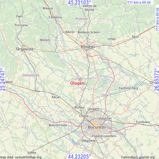
Ologeni GPS coordinates[2]
44° 44' 1.32" North, 25° 57' 2.124" East
| Map corner | latitude | longitude |
|---|---|---|
| Upper-left | 45.23103°, | 25.24747° |
| Center: | 44.7337°, | 25.95059° |
| Lower-right: | 44.23205°, | 26.65372° |
| Map W x H: | 111.1×111.1 km | = 69×69mi |
| max Lat: | 48.23793° ⇑78.8% North |
| Ologeni: | 44.7337° |
| min Lat: | ⇓21.2% South 43.65638° |
| min Long | Ologeni | max Long |
| 20.31667° | 25.95059° | 29.65403° |
| W 62%⇐ | ⇒38% E |
Elevation
Elevation of Ologeni is 120 m = 394 ft, and this is 134.9 m = 443 ft below average elevation for this country.
| Max E: |
1278 m = 4193 ft | 71.9% |
| Avg. | 254.9 m = 836 ft | |
| Ologeni | 120 m = 394 ft | |
Min E: |
-2 m = -7 ft | 28.1% |
See also: Romania elevation on elevation.city.
Geographical zone
Ologeni is located in North temperate zone (between Tropic of Cancer and the Arctic Circle). Distance of this Northern Tropic circle is 2368 km =1471.4 mi to South.| Distance of | km | miles | from Ologeni |
|---|---|---|---|
| North Pole | 5033.1 | 3127.4 | to North |
| Arctic Circle | 2427.3 | 1508.3 | to North |
| Tropic Cancer | 2368 | 1471.4 | to South |
| Equator | 4973.9 | 3090.6 | to South |


Nearby cities:
15 places around Ologeni: (largest is in red/bold)
• Bujoreanca
4.7 km =2.9 mi,  266°
266°
• Buriaș
2.4 km =1.5 mi,  91°
91°
• Butimanu
6.9 km =4.3 mi,  215°
215°
• Ciocănari
4.5 km =2.8 mi,  152°
152°
• Cătunu
5 km =3.1 mi,  280°
280°
• Fântânele
6.9 km =4.3 mi,  254°
254°
• Hăbud
5 km =3.1 mi,  343°
343°
• Movila
6.2 km =3.9 mi,  164°
164°
• Niculești
5.7 km =3.5 mi,  186°
186°
• Periş
7.4 km =4.6 mi,  137°
137°
• Poienarii Burchii
5.5 km =3.4 mi,  70°
70°
• Poienarii-Rali
6.8 km =4.2 mi, 74°
• Tăriceni
7.1 km =4.4 mi,  12°
12°
• Tătărăi
1.7 km =1.1 mi, 284°
• Ungureni
6.9 km =4.3 mi,  324°
324°
Sources, notices
• [Note1] Compared only with cities in Romania existing in our database
• [Src1] Map data: © OpenStreetMap contributors (CC-BY-SA)
• [Src2] Other city data from geonames.org with taken over terms of usage.
• [Src3] Geographical zone / Annual Mean Temperature by Robert A. Rohde @ Wikipedia
