Hotar geodata
Hotar (Bihor) is a populated place; located in Romania in Europe/Bucharest (GMT+3) time zone. With population of 1,091 people, there are 4014 cities with bigger population in this country. Compared to other cities in Romania, 79.5% of cities are located further ↓South; 91.9% of cities are located further →East and 52.8% of cities have lower elevation than Hotar. Note1


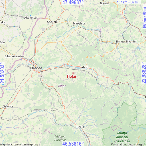
Hotar GPS coordinates[2]
47° 1' 10.812" North, 22° 17' 6.54" East
| Map corner | latitude | longitude |
|---|---|---|
| Upper-left | 47.49687°, | 21.58203° |
| Center: | 47.01967°, | 22.28515° |
| Lower-right: | 46.53816°, | 22.98828° |
| Map W x H: | 106.6×106.6 km | = 66.2×66.2mi |
| max Lat: | 48.23793° ⇑20.5% North |
| Hotar: | 47.01967° |
| min Lat: | ⇓79.5% South 43.65638° |
| min Long | Hotar | max Long |
| 20.31667° | 22.28515° | 29.65403° |
| W 8.1%⇐ | ⇒91.9% E |
Elevation
Elevation of Hotar is 226 m = 741 ft, and this is 28.9 m = 95 ft below average elevation for this country.
| Max E: |
1278 m = 4193 ft | 47.2% |
| Avg. | 254.9 m = 836 ft | |
| Hotar | 226 m = 741 ft | |
Min E: |
-2 m = -7 ft | 52.8% |
See also: Romania elevation on elevation.city.
Geographical zone
Hotar is located in North temperate zone (between Tropic of Cancer and the Arctic Circle). Distance of this North polar circle is 2173.1 km =1350.3 mi to North.| Distance of | km | miles | from Hotar |
|---|---|---|---|
| North Pole | 4779 | 2969.5 | to North |
| Arctic Circle | 2173.1 | 1350.3 | to North |
| Tropic Cancer | 2622.2 | 1629.4 | to South |
| Equator | 5228.1 | 3248.6 | to South |


Nearby cities:
15 places around Hotar: (largest is in red/bold)
• Aştileu
7.6 km =4.7 mi,  78°
78°
• Chistag
6.2 km =3.9 mi,  61°
61°
• Lugaşu de Jos
7.2 km =4.5 mi,  43°
43°
• Lugașu de Sus
8.5 km =5.3 mi, 39°
• Peștere
7.1 km =4.4 mi, 84°
• Subpiatră
1.8 km =1.1 mi,  69°
69°
• Surduc
8 km =5 mi,  232°
232°
• Telechiu
4 km =2.5 mi,  348°
348°
• Tileagd
8.3 km =5.2 mi,  309°
309°
• Tilecuș
5.1 km =3.2 mi,  273°
273°
• Uileacu de Criș
8.7 km =5.4 mi,  321°
321°
• Urvind
5.3 km =3.3 mi,  358°
358°
• Vârciorog
6 km =3.7 mi,  169°
169°
• Șerghiș
5.5 km =3.4 mi,  218°
218°
• Țețchea
4.2 km =2.6 mi,  45°
45°
Sources, notices
• [Note1] Compared only with cities in Romania existing in our database
• [Src1] Map data: © OpenStreetMap contributors (CC-BY-SA)
• [Src2] Other city data from geonames.org with taken over terms of usage.
• [Src3] Geographical zone / Annual Mean Temperature by Robert A. Rohde @ Wikipedia
