Studinița geodata
Studinița (Olt) is a populated place; located in Romania in Europe/Bucharest (GMT+3) time zone. With population of 1,391 people, there are 3352 cities with bigger population in this country. Compared to other cities in Romania, 97.3% of cities are located further ↑North; 61.3% of cities are located further →East and 85.1% of cities have higher elevation than Studinița. Note1


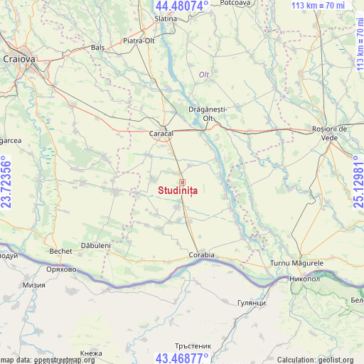
Studinița GPS coordinates[2]
43° 58' 36.876" North, 24° 25' 36.048" East
| Map corner | latitude | longitude |
|---|---|---|
| Upper-left | 44.48074°, | 23.72356° |
| Center: | 43.97691°, | 24.42668° |
| Lower-right: | 43.46877°, | 25.12981° |
| Map W x H: | 112.5×112.5 km | = 69.9×69.9mi |
| max Lat: | 48.23793° ⇑97.3% North |
| Studinița: | 43.97691° |
| min Lat: | ⇓2.7% South 43.65638° |
| min Long | Studinița | max Long |
| 20.31667° | 24.42668° | 29.65403° |
| W 38.7%⇐ | ⇒61.3% E |
Elevation
Elevation of Studinița is 78 m = 256 ft, and this is 176.9 m = 580 ft below average elevation for this country.
| Max E: |
1278 m = 4193 ft | 85.1% |
| Avg. | 254.9 m = 836 ft | |
| Studinița | 78 m = 256 ft | |
Min E: |
-2 m = -7 ft | 14.9% |
See also: Romania elevation on elevation.city.
Geographical zone
Studinița is located in North temperate zone (between Tropic of Cancer and the Arctic Circle). Distance of this Northern Tropic circle is 2283.9 km =1419.1 mi to South.| Distance of | km | miles | from Studinița |
|---|---|---|---|
| North Pole | 5117.3 | 3179.7 | to North |
| Arctic Circle | 2511.4 | 1560.5 | to North |
| Tropic Cancer | 2283.9 | 1419.1 | to South |
| Equator | 4889.8 | 3038.4 | to South |


Nearby cities:
15 places around Studinița: (largest is in red/bold)
• Arvăteasca
4.3 km =2.7 mi,  228°
228°
• Brastavățu
8 km =5 mi,  190°
190°
• Comanca
12.5 km =7.8 mi,  334°
334°
• Crușovu
5.9 km =3.7 mi, 189°
• Deveselu
10.6 km =6.6 mi,  340°
340°
• Grădinile
4.4 km =2.7 mi,  219°
219°
• Plăviceni
12.2 km =7.6 mi,  92°
92°
• Redișoara
9.7 km =6 mi,  318°
318°
• Rotunda
8.8 km =5.5 mi,  274°
274°
• Scărişoara
11.5 km =7.1 mi,  77°
77°
• Studina
1.4 km =0.9 mi, 215°
• Traian
4.8 km =3 mi,  22°
22°
• Vişina
12.4 km =7.7 mi,  171°
171°
• Vișina Nouă
11.4 km =7.1 mi,  183°
183°
• Vlădila
3.3 km =2.1 mi, 320°
Sources, notices
• [Note1] Compared only with cities in Romania existing in our database
• [Src1] Map data: © OpenStreetMap contributors (CC-BY-SA)
• [Src2] Other city data from geonames.org with taken over terms of usage.
• [Src3] Geographical zone / Annual Mean Temperature by Robert A. Rohde @ Wikipedia
