Redișoara geodata
Redișoara (Olt) is a populated place; located in Romania in Europe/Bucharest (GMT+3) time zone. With population of 666 people, there are 5775 cities with bigger population in this country. Compared to other cities in Romania, 96.3% of cities are located further ↑North; 62.9% of cities are located further →East and 73.3% of cities have higher elevation than Redișoara. Note1


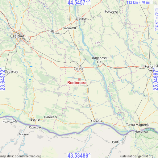
Redișoara GPS coordinates[2]
44° 2' 32.784" North, 24° 20' 48.624" East
| Map corner | latitude | longitude |
|---|---|---|
| Upper-left | 44.54571°, | 23.64372° |
| Center: | 44.04244°, | 24.34684° |
| Lower-right: | 43.53486°, | 25.04997° |
| Map W x H: | 112.4×112.4 km | = 69.8×69.8mi |
| max Lat: | 48.23793° ⇑96.3% North |
| Redișoara: | 44.04244° |
| min Lat: | ⇓3.7% South 43.65638° |
| min Long | Redișoara | max Long |
| 20.31667° | 24.34684° | 29.65403° |
| W 37.1%⇐ | ⇒62.9% E |
Elevation
Elevation of Redișoara is 116 m = 381 ft, and this is 138.9 m = 456 ft below average elevation for this country.
| Max E: |
1278 m = 4193 ft | 73.3% |
| Avg. | 254.9 m = 836 ft | |
| Redișoara | 116 m = 381 ft | |
Min E: |
-2 m = -7 ft | 26.7% |
See also: Romania elevation on elevation.city.
Geographical zone
Redișoara is located in North temperate zone (between Tropic of Cancer and the Arctic Circle). Distance of this Northern Tropic circle is 2291.1 km =1423.6 mi to South.| Distance of | km | miles | from Redișoara |
|---|---|---|---|
| North Pole | 5110 | 3175.2 | to North |
| Arctic Circle | 2504.1 | 1556 | to North |
| Tropic Cancer | 2291.1 | 1423.6 | to South |
| Equator | 4897.1 | 3042.9 | to South |


Nearby cities:
15 places around Redișoara: (largest is in red/bold)
• Arvăteasca
10.6 km =6.6 mi,  162°
162°
• Bucinişu
12.9 km =8 mi,  217°
217°
• Caracal
8.3 km =5.2 mi,  1°
1°
• Comanca
4.1 km =2.5 mi,  13°
13°
• Deveselu
4 km =2.5 mi,  47°
47°
• Drăghiceni
12.7 km =7.9 mi,  322°
322°
• Grozăvești
13.2 km =8.2 mi, 318°
• Grădinile
11.3 km =7 mi, 161°
• Liiceni
10.6 km =6.6 mi,  327°
327°
• Redea
3.8 km =2.4 mi,  282°
282°
• Rotunda
7 km =4.3 mi,  200°
200°
• Studina
10.1 km =6.3 mi,  146°
146°
• Studinița
9.7 km =6 mi,  138°
138°
• Traian
8.7 km =5.4 mi,  109°
109°
• Vlădila
6.4 km =4 mi, 137°
Sources, notices
• [Note1] Compared only with cities in Romania existing in our database
• [Src1] Map data: © OpenStreetMap contributors (CC-BY-SA)
• [Src2] Other city data from geonames.org with taken over terms of usage.
• [Src3] Geographical zone / Annual Mean Temperature by Robert A. Rohde @ Wikipedia
