Șomoșcheș geodata
Șomoșcheș (Arad) is a populated place; located in Romania in Europe/Bucharest (GMT+3) time zone. With population of 983 people, there are 4346 cities with bigger population in this country. Compared to other cities in Romania, 68.8% of cities are located further ↓South; 95.5% of cities are located further →East and 75.9% of cities have higher elevation than Șomoșcheș. Note1


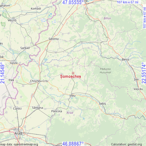
Șomoșcheș GPS coordinates[2]
46° 34' 26.976" North, 21° 50' 54.996" East
| Map corner | latitude | longitude |
|---|---|---|
| Upper-left | 47.05535°, | 21.14549° |
| Center: | 46.57416°, | 21.84861° |
| Lower-right: | 46.08867°, | 22.55174° |
| Map W x H: | 107.5×107.5 km | = 66.8×66.8mi |
| max Lat: | 48.23793° ⇑31.2% North |
| Șomoșcheș: | 46.57416° |
| min Lat: | ⇓68.8% South 43.65638° |
| min Long | Șomoșcheș | max Long |
| 20.31667° | 21.84861° | 29.65403° |
| W 4.5%⇐ | ⇒95.5% E |
Elevation
Elevation of Șomoșcheș is 107 m = 351 ft, and this is 147.9 m = 485 ft below average elevation for this country.
| Max E: |
1278 m = 4193 ft | 75.9% |
| Avg. | 254.9 m = 836 ft | |
| Șomoșcheș | 107 m = 351 ft | |
Min E: |
-2 m = -7 ft | 24.1% |
See also: Romania elevation on elevation.city.
Geographical zone
Șomoșcheș is located in North temperate zone (between Tropic of Cancer and the Arctic Circle). Distance of this North polar circle is 2222.6 km =1381.1 mi to North.| Distance of | km | miles | from Șomoșcheș |
|---|---|---|---|
| North Pole | 4828.5 | 3000.3 | to North |
| Arctic Circle | 2222.6 | 1381.1 | to North |
| Tropic Cancer | 2572.6 | 1598.5 | to South |
| Equator | 5178.6 | 3217.8 | to South |


Nearby cities:
15 places around Șomoșcheș: (largest is in red/bold)
• Apateu
6.9 km =4.3 mi,  313°
313°
• Batăr
14.2 km =8.8 mi,  350°
350°
• Beliu
14.4 km =8.9 mi,  134°
134°
• Berechiu
7.2 km =4.5 mi,  358°
358°
• Cermei
2.7 km =1.7 mi,  177°
177°
• Chișlaca
8.9 km =5.5 mi,  104°
104°
• Craiva
9.1 km =5.7 mi,  83°
83°
• Călacea
13.1 km =8.1 mi,  29°
29°
• Gurba
12.7 km =7.9 mi,  201°
201°
• Satu Nou
12.4 km =7.7 mi,  295°
295°
• Susag
6.6 km =4.1 mi,  51°
51°
• Talpoș
13.5 km =8.4 mi, 345°
• Tăgădău
13.8 km =8.6 mi,  122°
122°
• Ucuriș
10.9 km =6.8 mi, 49°
• Șepreuș
8.8 km =5.5 mi,  267°
267°
Sources, notices
• [Note1] Compared only with cities in Romania existing in our database
• [Src1] Map data: © OpenStreetMap contributors (CC-BY-SA)
• [Src2] Other city data from geonames.org with taken over terms of usage.
• [Src3] Geographical zone / Annual Mean Temperature by Robert A. Rohde @ Wikipedia
