Sohodor geodata
Sohodor (Bacău) is a populated place; located in Romania in Europe/Bucharest (GMT+3) time zone. With population of 638 people, there are 5954 cities with bigger population in this country. Compared to other cities in Romania, 64.8% of cities are located further ↓South; 84.2% of cities are located further ←West and 63.7% of cities have higher elevation than Sohodor. Note1


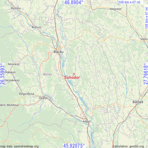
Sohodor GPS coordinates[2]
46° 24' 27.828" North, 27° 3' 46.98" East
| Map corner | latitude | longitude |
|---|---|---|
| Upper-left | 46.8904°, | 26.35993° |
| Center: | 46.40773°, | 27.06305° |
| Lower-right: | 45.92075°, | 27.76618° |
| Map W x H: | 107.8×107.8 km | = 67×67mi |
| max Lat: | 48.23793° ⇑35.2% North |
| Sohodor: | 46.40773° |
| min Lat: | ⇓64.8% South 43.65638° |
| min Long | Sohodor | max Long |
| 20.31667° | 27.06305° | 29.65403° |
| W 84.2%⇐ | ⇒15.8% E |
Elevation
Elevation of Sohodor is 152 m = 499 ft, and this is 102.9 m = 338 ft below average elevation for this country.
| Max E: |
1278 m = 4193 ft | 63.7% |
| Avg. | 254.9 m = 836 ft | |
| Sohodor | 152 m = 499 ft | |
Min E: |
-2 m = -7 ft | 36.3% |
See also: Romania elevation on elevation.city.
Geographical zone
Sohodor is located in North temperate zone (between Tropic of Cancer and the Arctic Circle). Distance of this North polar circle is 2241.1 km =1392.6 mi to North.| Distance of | km | miles | from Sohodor |
|---|---|---|---|
| North Pole | 4847 | 3011.8 | to North |
| Arctic Circle | 2241.1 | 1392.6 | to North |
| Tropic Cancer | 2554.1 | 1587 | to South |
| Equator | 5160.1 | 3206.3 | to South |


Nearby cities:
15 places around Sohodor: (largest is in red/bold)
• Bazga
4.3 km =2.7 mi,  224°
224°
• Chetriș
8.5 km =5.3 mi,  319°
319°
• Dieneț
10.1 km =6.3 mi,  178°
178°
• Gheorghe Doja
8.4 km =5.2 mi,  247°
247°
• Gioseni
5.9 km =3.7 mi,  293°
293°
• Horgeşti
2.9 km =1.8 mi,  5°
5°
• Nănești
6.5 km =4 mi,  36°
36°
• Parincea
8.9 km =5.5 mi,  18°
18°
• Petrești
4.6 km =2.9 mi,  120°
120°
• Pănceşti
8.4 km =5.2 mi,  169°
169°
• Recea
1.9 km =1.2 mi,  199°
199°
• Soci
5.4 km =3.4 mi,  89°
89°
• Valea Mică
9.2 km =5.7 mi,  258°
258°
• Vladnic
7.1 km =4.4 mi,  53°
53°
• Văleni
6.6 km =4.1 mi, 9°
Sources, notices
• [Note1] Compared only with cities in Romania existing in our database
• [Src1] Map data: © OpenStreetMap contributors (CC-BY-SA)
• [Src2] Other city data from geonames.org with taken over terms of usage.
• [Src3] Geographical zone / Annual Mean Temperature by Robert A. Rohde @ Wikipedia
