Bazga geodata
Bazga (Bacău) is a populated place; located in Romania in Europe/Bucharest (GMT+3) time zone. With population of 567 people, there are 6452 cities with bigger population in this country. Compared to other cities in Romania, 64% of cities are located further ↓South; 83.4% of cities are located further ←West and 62% of cities have higher elevation than Bazga. Note1


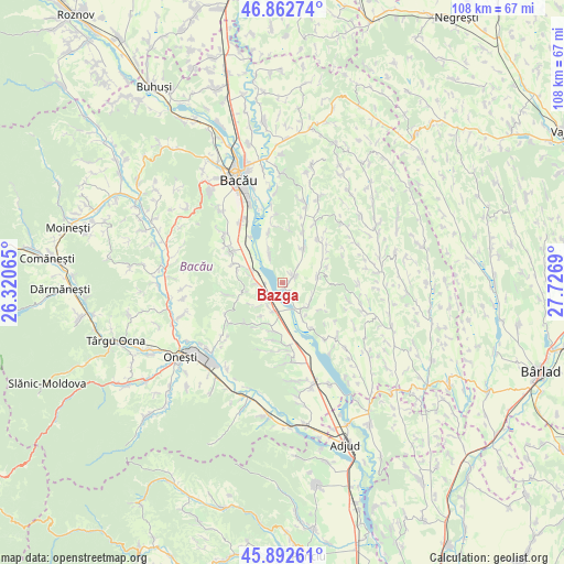
Bazga GPS coordinates[2]
46° 22' 47.388" North, 27° 1' 25.572" East
| Map corner | latitude | longitude |
|---|---|---|
| Upper-left | 46.86274°, | 26.32065° |
| Center: | 46.37983°, | 27.02377° |
| Lower-right: | 45.89261°, | 27.7269° |
| Map W x H: | 107.9×107.9 km | = 67×67mi |
| max Lat: | 48.23793° ⇑36% North |
| Bazga: | 46.37983° |
| min Lat: | ⇓64% South 43.65638° |
| min Long | Bazga | max Long |
| 20.31667° | 27.02377° | 29.65403° |
| W 83.4%⇐ | ⇒16.6% E |
Elevation
Elevation of Bazga is 159 m = 522 ft, and this is 95.9 m = 315 ft below average elevation for this country.
| Max E: |
1278 m = 4193 ft | 62% |
| Avg. | 254.9 m = 836 ft | |
| Bazga | 159 m = 522 ft | |
Min E: |
-2 m = -7 ft | 38% |
See also: Romania elevation on elevation.city.
Geographical zone
Bazga is located in North temperate zone (between Tropic of Cancer and the Arctic Circle). Distance of this North polar circle is 2244.2 km =1394.5 mi to North.| Distance of | km | miles | from Bazga |
|---|---|---|---|
| North Pole | 4850.1 | 3013.7 | to North |
| Arctic Circle | 2244.2 | 1394.5 | to North |
| Tropic Cancer | 2551 | 1585.1 | to South |
| Equator | 5157 | 3204.4 | to South |


Nearby cities:
15 places around Bazga: (largest is in red/bold)
• Ciucani
7.1 km =4.4 mi,  258°
258°
• Dieneț
7.8 km =4.8 mi,  154°
154°
• Drăgușani
9.5 km =5.9 mi,  197°
197°
• Gheorghe Doja
4.7 km =2.9 mi,  267°
267°
• Gioseni
6 km =3.7 mi,  336°
336°
• Horgeşti
6.8 km =4.2 mi,  28°
28°
• Parava
9.1 km =5.7 mi,  191°
191°
• Petrești
7 km =4.3 mi,  83°
83°
• Pănceşti
6.9 km =4.3 mi,  138°
138°
• Recea
2.7 km =1.7 mi,  61°
61°
• Răcăciuni
6 km =3.7 mi,  210°
210°
• Soci
9 km =5.6 mi,  69°
69°
• Sohodor
4.3 km =2.7 mi,  44°
44°
• Somușca
8.9 km =5.5 mi,  285°
285°
• Valea Mică
6.2 km =3.9 mi,  281°
281°
Sources, notices
• [Note1] Compared only with cities in Romania existing in our database
• [Src1] Map data: © OpenStreetMap contributors (CC-BY-SA)
• [Src2] Other city data from geonames.org with taken over terms of usage.
• [Src3] Geographical zone / Annual Mean Temperature by Robert A. Rohde @ Wikipedia
