Nănești geodata
Nănești (Bacău) is a populated place; located in Romania in Europe/Bucharest (GMT+3) time zone. With population of 835 people, there are 4903 cities with bigger population in this country. Compared to other cities in Romania, 66% of cities are located further ↓South; 85.4% of cities are located further ←West and 56.9% of cities have lower elevation than Nănești. Note1


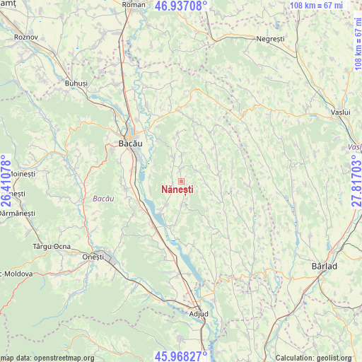
Nănești GPS coordinates[2]
46° 27' 17.388" North, 27° 6' 50.04" East
| Map corner | latitude | longitude |
|---|---|---|
| Upper-left | 46.93708°, | 26.41078° |
| Center: | 46.45483°, | 27.1139° |
| Lower-right: | 45.96827°, | 27.81703° |
| Map W x H: | 107.7×107.7 km | = 66.9×66.9mi |
| max Lat: | 48.23793° ⇑34% North |
| Nănești: | 46.45483° |
| min Lat: | ⇓66% South 43.65638° |
| min Long | Nănești | max Long |
| 20.31667° | 27.1139° | 29.65403° |
| W 85.4%⇐ | ⇒14.6% E |
Elevation
Elevation of Nănești is 247 m = 810 ft, and this is 7.9 m = 26 ft below average elevation for this country.
| Max E: |
1278 m = 4193 ft | 43.1% |
| Avg. | 254.9 m = 836 ft | |
| Nănești | 247 m = 810 ft | |
Min E: |
-2 m = -7 ft | 56.9% |
See also: Romania elevation on elevation.city.
Geographical zone
Nănești is located in North temperate zone (between Tropic of Cancer and the Arctic Circle). Distance of this North polar circle is 2235.9 km =1389.3 mi to North.| Distance of | km | miles | from Nănești |
|---|---|---|---|
| North Pole | 4841.8 | 3008.6 | to North |
| Arctic Circle | 2235.9 | 1389.3 | to North |
| Tropic Cancer | 2559.4 | 1590.3 | to South |
| Equator | 5165.3 | 3209.6 | to South |


Nearby cities:
15 places around Nănești: (largest is in red/bold)
• Bibirești
7.6 km =4.7 mi,  338°
338°
• Chetriș
9.4 km =5.8 mi,  277°
277°
• Filipeni
10.2 km =6.3 mi,  31°
31°
• Gioseni
9.7 km =6 mi,  253°
253°
• Horgeşti
4.3 km =2.7 mi,  236°
236°
• Onceşti
10.5 km =6.5 mi,  82°
82°
• Parincea
3.3 km =2.1 mi, 341°
• Petrești
7.5 km =4.7 mi,  179°
179°
• Recea
8.4 km =5.2 mi,  212°
212°
• Soci
5.4 km =3.4 mi,  163°
163°
• Sohodor
6.5 km =4 mi,  216°
216°
• Tamaşi
10.5 km =6.5 mi,  287°
287°
• Ungureni
7.6 km =4.7 mi,  358°
358°
• Vladnic
2.1 km =1.3 mi,  119°
119°
• Văleni
3.1 km =1.9 mi, 294°
Sources, notices
• [Note1] Compared only with cities in Romania existing in our database
• [Src1] Map data: © OpenStreetMap contributors (CC-BY-SA)
• [Src2] Other city data from geonames.org with taken over terms of usage.
• [Src3] Geographical zone / Annual Mean Temperature by Robert A. Rohde @ Wikipedia
