Seceani geodata
Seceani (Timiş) is a populated place; located in Romania in Europe/Bucharest (GMT+3) time zone. With population of 595 people, there are 6241 cities with bigger population in this country. Compared to other cities in Romania, 54.6% of cities are located further ↓South; 98.3% of cities are located further →East and 57.1% of cities have higher elevation than Seceani. Note1


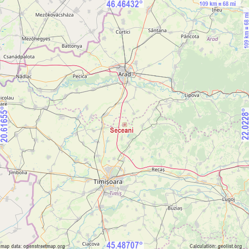
Seceani GPS coordinates[2]
45° 58' 40.26" North, 21° 19' 10.812" East
| Map corner | latitude | longitude |
|---|---|---|
| Upper-left | 46.46432°, | 20.61655° |
| Center: | 45.97785°, | 21.31967° |
| Lower-right: | 45.48707°, | 22.0228° |
| Map W x H: | 108.7×108.7 km | = 67.5×67.5mi |
| max Lat: | 48.23793° ⇑45.4% North |
| Seceani: | 45.97785° |
| min Lat: | ⇓54.6% South 43.65638° |
| min Long | Seceani | max Long |
| 20.31667° | 21.31967° | 29.65403° |
| W 1.7%⇐ | ⇒98.3% E |
Elevation
Elevation of Seceani is 178 m = 584 ft, and this is 76.9 m = 252 ft below average elevation for this country.
| Max E: |
1278 m = 4193 ft | 57.1% |
| Avg. | 254.9 m = 836 ft | |
| Seceani | 178 m = 584 ft | |
Min E: |
-2 m = -7 ft | 42.9% |
See also: Romania elevation on elevation.city.
Geographical zone
Seceani is located in North temperate zone (between Tropic of Cancer and the Arctic Circle). Distance of this North polar circle is 2288.9 km =1422.3 mi to North.| Distance of | km | miles | from Seceani |
|---|---|---|---|
| North Pole | 4894.8 | 3041.5 | to North |
| Arctic Circle | 2288.9 | 1422.3 | to North |
| Tropic Cancer | 2506.3 | 1557.3 | to South |
| Equator | 5112.3 | 3176.6 | to South |


Nearby cities:
15 places around Seceani: (largest is in red/bold)
• Alioș
15 km =9.3 mi,  63°
63°
• Bencecu de Sus
13.4 km =8.3 mi,  141°
141°
• Carani
14.6 km =9.1 mi,  239°
239°
• Cornești
10.3 km =6.4 mi,  224°
224°
• Cruceni
10.2 km =6.3 mi,  7°
7°
• Călacea
13.6 km =8.5 mi,  258°
258°
• Fibiș
8 km =5 mi,  94°
94°
• Fiscut
8.3 km =5.2 mi,  45°
45°
• Maşloc
10.3 km =6.4 mi,  77°
77°
• Murani
6 km =3.7 mi,  190°
190°
• Mănăștur
14.8 km =9.2 mi,  283°
283°
• Orţişoara
9.5 km =5.9 mi, 260°
• Pişchia
8.4 km =5.2 mi,  170°
170°
• Vinga
10.2 km =6.3 mi,  295°
295°
• Şagu
8.5 km =5.3 mi,  340°
340°
Sources, notices
• [Note1] Compared only with cities in Romania existing in our database
• [Src1] Map data: © OpenStreetMap contributors (CC-BY-SA)
• [Src2] Other city data from geonames.org with taken over terms of usage.
• [Src3] Geographical zone / Annual Mean Temperature by Robert A. Rohde @ Wikipedia
