Orţişoara geodata
Orţişoara (Timiş) is a seat of a second-order administrative division; located in Romania in Europe/Bucharest (GMT+3) time zone. With population of 4,042 people, there are 1148 cities with bigger population in this country. Compared to other cities in Romania, 54.2% of cities are located further ↓South; 98.7% of cities are located further →East and 71.2% of cities have higher elevation than Orţişoara. Note1


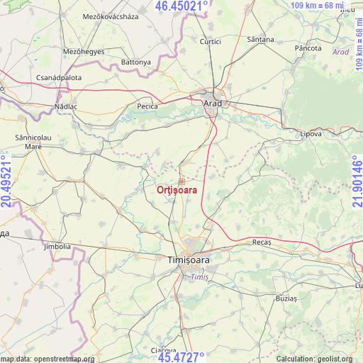
Orţişoara GPS coordinates[2]
45° 57' 48.996" North, 21° 11' 53.988" East
| Map corner | latitude | longitude |
|---|---|---|
| Upper-left | 46.45021°, | 20.49521° |
| Center: | 45.96361°, | 21.19833° |
| Lower-right: | 45.4727°, | 21.90146° |
| Map W x H: | 108.7×108.7 km | = 67.5×67.5mi |
| max Lat: | 48.23793° ⇑45.8% North |
| Orţişoara: | 45.96361° |
| min Lat: | ⇓54.2% South 43.65638° |
| min Long | Orţişoara | max Long |
| 20.31667° | 21.19833° | 29.65403° |
| W 1.3%⇐ | ⇒98.7% E |
Elevation
Elevation of Orţişoara is 123 m = 404 ft, and this is 131.9 m = 433 ft below average elevation for this country.
| Max E: |
1278 m = 4193 ft | 71.2% |
| Avg. | 254.9 m = 836 ft | |
| Orţişoara | 123 m = 404 ft | |
Min E: |
-2 m = -7 ft | 28.8% |
See also: Romania elevation on elevation.city.
Geographical zone
Orţişoara is located in North temperate zone (between Tropic of Cancer and the Arctic Circle). Distance of this North polar circle is 2290.5 km =1423.3 mi to North.| Distance of | km | miles | from Orţişoara |
|---|---|---|---|
| North Pole | 4896.4 | 3042.5 | to North |
| Arctic Circle | 2290.5 | 1423.3 | to North |
| Tropic Cancer | 2504.8 | 1556.4 | to South |
| Equator | 5110.7 | 3175.6 | to South |


Nearby cities:
15 places around Orţişoara: (largest is in red/bold)
• Bărăteaz
7.9 km =4.9 mi,  274°
274°
• Carani
6.7 km =4.2 mi,  208°
208°
• Cornești
6.1 km =3.8 mi,  159°
159°
• Călacea
4.1 km =2.5 mi,  252°
252°
• Gelu
11.7 km =7.3 mi,  293°
293°
• Hodoni
10.6 km =6.6 mi,  233°
233°
• Mailat
11.2 km =7 mi,  320°
320°
• Murani
9.3 km =5.8 mi,  117°
117°
• Mănăștur
7.1 km =4.4 mi, 315°
• Pişchia
12.7 km =7.9 mi, 122°
• Satchinez
12.5 km =7.8 mi,  256°
256°
• Seceani
9.5 km =5.9 mi,  80°
80°
• Sânandrei
12.5 km =7.8 mi,  190°
190°
• Vinga
5.9 km =3.7 mi,  1°
1°
• Şagu
11.6 km =7.2 mi,  34°
34°
Sources, notices
• [Note1] Compared only with cities in Romania existing in our database
• [Src1] Map data: © OpenStreetMap contributors (CC-BY-SA)
• [Src2] Other city data from geonames.org with taken over terms of usage.
• [Src3] Geographical zone / Annual Mean Temperature by Robert A. Rohde @ Wikipedia
