Şagu geodata
Şagu (Arad) is a seat of a second-order administrative division; located in Romania in Europe/Bucharest (GMT+3) time zone. With population of 3,797 people, there are 1266 cities with bigger population in this country. Compared to other cities in Romania, 56% of cities are located further ↓South; 98.4% of cities are located further →East and 67.7% of cities have higher elevation than Şagu. Note1


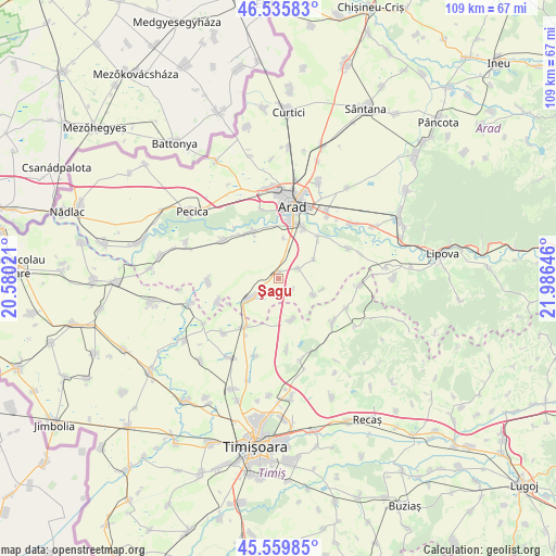
Şagu GPS coordinates[2]
46° 3' 0" North, 21° 16' 59.988" East
| Map corner | latitude | longitude |
|---|---|---|
| Upper-left | 46.53583°, | 20.58021° |
| Center: | 46.05°, | 21.28333° |
| Lower-right: | 45.55985°, | 21.98646° |
| Map W x H: | 108.5×108.5 km | = 67.4×67.4mi |
| max Lat: | 48.23793° ⇑44% North |
| Şagu: | 46.05° |
| min Lat: | ⇓56% South 43.65638° |
| min Long | Şagu | max Long |
| 20.31667° | 21.28333° | 29.65403° |
| W 1.6%⇐ | ⇒98.4% E |
Elevation
Elevation of Şagu is 136 m = 446 ft, and this is 118.9 m = 390 ft below average elevation for this country.
| Max E: |
1278 m = 4193 ft | 67.7% |
| Avg. | 254.9 m = 836 ft | |
| Şagu | 136 m = 446 ft | |
Min E: |
-2 m = -7 ft | 32.3% |
See also: Romania elevation on elevation.city.
Geographical zone
Şagu is located in North temperate zone (between Tropic of Cancer and the Arctic Circle). Distance of this North polar circle is 2280.9 km =1417.3 mi to North.| Distance of | km | miles | from Şagu |
|---|---|---|---|
| North Pole | 4886.8 | 3036.5 | to North |
| Arctic Circle | 2280.9 | 1417.3 | to North |
| Tropic Cancer | 2514.4 | 1562.4 | to South |
| Equator | 5120.3 | 3181.6 | to South |


Nearby cities:
15 places around Şagu: (largest is in red/bold)
• Arad
15 km =9.3 mi,  9°
9°
• Cruceni
4.6 km =2.9 mi,  62°
62°
• Felnac
12.7 km =7.9 mi,  305°
305°
• Fibiș
13.8 km =8.6 mi,  128°
128°
• Fiscut
9 km =5.6 mi,  103°
103°
• Frumușeni
14.9 km =9.3 mi,  66°
66°
• Fântânele
11.3 km =7 mi,  43°
43°
• Mailat
13.6 km =8.5 mi,  266°
266°
• Maşloc
14.1 km =8.8 mi,  114°
114°
• Murani
14 km =8.7 mi,  173°
173°
• Mănăștur
12.4 km =7.7 mi,  248°
248°
• Orţişoara
11.6 km =7.2 mi,  214°
214°
• Seceani
8.5 km =5.3 mi,  160°
160°
• Vinga
7.4 km =4.6 mi,  240°
240°
• Zădăreni
10.5 km =6.5 mi,  331°
331°
Sources, notices
• [Note1] Compared only with cities in Romania existing in our database
• [Src1] Map data: © OpenStreetMap contributors (CC-BY-SA)
• [Src2] Other city data from geonames.org with taken over terms of usage.
• [Src3] Geographical zone / Annual Mean Temperature by Robert A. Rohde @ Wikipedia
