Secara geodata
Secara (Teleorman) is a populated place; located in Romania in Europe/Bucharest (GMT+3) time zone. With population of 593 people, there are 6250 cities with bigger population in this country. Compared to other cities in Romania, 99.1% of cities are located further ↑North; 51.4% of cities are located further →East and 86.8% of cities have higher elevation than Secara. Note1


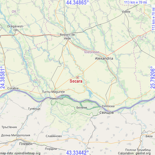
Secara GPS coordinates[2]
43° 50' 37.284" North, 25° 5' 20.148" East
| Map corner | latitude | longitude |
|---|---|---|
| Upper-left | 44.34865°, | 24.38581° |
| Center: | 43.84369°, | 25.08893° |
| Lower-right: | 43.33442°, | 25.79206° |
| Map W x H: | 112.8×112.8 km | = 70.1×70.1mi |
| max Lat: | 48.23793° ⇑99.1% North |
| Secara: | 43.84369° |
| min Lat: | ⇓0.9% South 43.65638° |
| min Long | Secara | max Long |
| 20.31667° | 25.08893° | 29.65403° |
| W 48.6%⇐ | ⇒51.4% E |
Elevation
Elevation of Secara is 72 m = 236 ft, and this is 182.9 m = 600 ft below average elevation for this country.
| Max E: |
1278 m = 4193 ft | 86.8% |
| Avg. | 254.9 m = 836 ft | |
| Secara | 72 m = 236 ft | |
Min E: |
-2 m = -7 ft | 13.2% |
See also: Romania elevation on elevation.city.
Geographical zone
Secara is located in North temperate zone (between Tropic of Cancer and the Arctic Circle). Distance of this Northern Tropic circle is 2269 km =1409.9 mi to South.| Distance of | km | miles | from Secara |
|---|---|---|---|
| North Pole | 5132.1 | 3188.9 | to North |
| Arctic Circle | 2526.2 | 1569.7 | to North |
| Tropic Cancer | 2269 | 1409.9 | to South |
| Equator | 4875 | 3029.2 | to South |


Nearby cities:
15 places around Secara: (largest is in red/bold)
• Bogdana
10 km =6.2 mi,  357°
357°
• Crângu
1.3 km =0.8 mi,  282°
282°
• Dracea
3 km =1.9 mi, 281°
• Furculești
5.3 km =3.3 mi,  53°
53°
• Lisa
6 km =3.7 mi,  143°
143°
• Moșteni
4.7 km =2.9 mi,  65°
65°
• Năvodari
11.3 km =7 mi,  177°
177°
• Piatra
6.9 km =4.3 mi,  115°
115°
• Seaca
10.6 km =6.6 mi,  189°
189°
• Spătărei
6.3 km =3.9 mi,  37°
37°
• Traian
11.1 km =6.9 mi,  219°
219°
• Ulmeni
6.6 km =4.1 mi,  9°
9°
• Viişoara
9.2 km =5.7 mi, 137°
• Voievoda
3.9 km =2.4 mi,  93°
93°
• Vânători
11.4 km =7.1 mi,  152°
152°
Sources, notices
• [Note1] Compared only with cities in Romania existing in our database
• [Src1] Map data: © OpenStreetMap contributors (CC-BY-SA)
• [Src2] Other city data from geonames.org with taken over terms of usage.
• [Src3] Geographical zone / Annual Mean Temperature by Robert A. Rohde @ Wikipedia
