Moșteni geodata
Moșteni (Teleorman) is a populated place; located in Romania in Europe/Bucharest (GMT+3) time zone. With population of 584 people, there are 6334 cities with bigger population in this country. Compared to other cities in Romania, 98.9% of cities are located further ↑North; 50.7% of cities are located further →East and 95.3% of cities have higher elevation than Moșteni. Note1


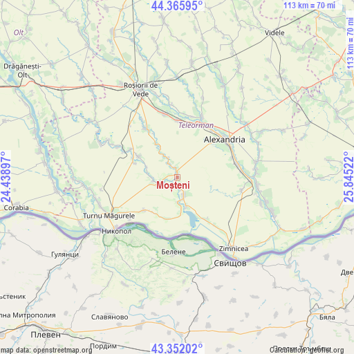
Moșteni GPS coordinates[2]
43° 51' 40.104" North, 25° 8' 31.524" East
| Map corner | latitude | longitude |
|---|---|---|
| Upper-left | 44.36595°, | 24.43897° |
| Center: | 43.86114°, | 25.14209° |
| Lower-right: | 43.35202°, | 25.84522° |
| Map W x H: | 112.7×112.7 km | = 70×70mi |
| max Lat: | 48.23793° ⇑98.9% North |
| Moșteni: | 43.86114° |
| min Lat: | ⇓1.1% South 43.65638° |
| min Long | Moșteni | max Long |
| 20.31667° | 25.14209° | 29.65403° |
| W 49.3%⇐ | ⇒50.7% E |
Elevation
Elevation of Moșteni is 34 m = 112 ft, and this is 220.9 m = 725 ft below average elevation for this country.
| Max E: |
1278 m = 4193 ft | 95.3% |
| Avg. | 254.9 m = 836 ft | |
| Moșteni | 34 m = 112 ft | |
Min E: |
-2 m = -7 ft | 4.7% |
See also: Romania elevation on elevation.city.
Geographical zone
Moșteni is located in North temperate zone (between Tropic of Cancer and the Arctic Circle). Distance of this Northern Tropic circle is 2271 km =1411.1 mi to South.| Distance of | km | miles | from Moșteni |
|---|---|---|---|
| North Pole | 5130.2 | 3187.8 | to North |
| Arctic Circle | 2524.3 | 1568.5 | to North |
| Tropic Cancer | 2271 | 1411.1 | to South |
| Equator | 4876.9 | 3030.4 | to South |


Nearby cities:
15 places around Moșteni: (largest is in red/bold)
• Bogdana
9.3 km =5.8 mi,  329°
329°
• Crângu
5.7 km =3.5 mi,  253°
253°
• Dracea
7.4 km =4.6 mi,  259°
259°
• Furculești
1.2 km =0.7 mi,  2°
2°
• Lisa
6.8 km =4.2 mi,  185°
185°
• Năvodari
13.8 km =8.6 mi,  196°
196°
• Piatra
5.3 km =3.3 mi,  158°
158°
• Seaca
13.8 km =8.6 mi,  206°
206°
• Secara
4.7 km =2.9 mi, 245°
• Spătărei
3.1 km =1.9 mi,  351°
351°
• Ulmeni
5.6 km =3.5 mi, 325°
• Urluiu
12.6 km =7.8 mi, 325°
• Viişoara
8.9 km =5.5 mi,  167°
167°
• Voievoda
2.2 km =1.4 mi, 188°
• Vânători
12.1 km =7.5 mi,  175°
175°
Sources, notices
• [Note1] Compared only with cities in Romania existing in our database
• [Src1] Map data: © OpenStreetMap contributors (CC-BY-SA)
• [Src2] Other city data from geonames.org with taken over terms of usage.
• [Src3] Geographical zone / Annual Mean Temperature by Robert A. Rohde @ Wikipedia
