Crângu geodata
Crângu (Teleorman) is a seat of a second-order administrative division; located in Romania in Europe/Bucharest (GMT+3) time zone. With population of 1,242 people, there are 3654 cities with bigger population in this country. Compared to other cities in Romania, 99.1% of cities are located further ↑North; 51.6% of cities are located further →East and 94.7% of cities have higher elevation than Crângu. Note1


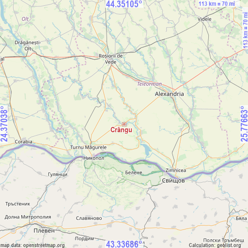
Crângu GPS coordinates[2]
43° 50' 45.996" North, 25° 4' 24.6" East
| Map corner | latitude | longitude |
|---|---|---|
| Upper-left | 44.35105°, | 24.37038° |
| Center: | 43.84611°, | 25.0735° |
| Lower-right: | 43.33686°, | 25.77663° |
| Map W x H: | 112.8×112.8 km | = 70.1×70.1mi |
| max Lat: | 48.23793° ⇑99.1% North |
| Crângu: | 43.84611° |
| min Lat: | ⇓0.9% South 43.65638° |
| min Long | Crângu | max Long |
| 20.31667° | 25.0735° | 29.65403° |
| W 48.4%⇐ | ⇒51.6% E |
Elevation
Elevation of Crângu is 36 m = 118 ft, and this is 218.9 m = 718 ft below average elevation for this country.
| Max E: |
1278 m = 4193 ft | 94.7% |
| Avg. | 254.9 m = 836 ft | |
| Crângu | 36 m = 118 ft | |
Min E: |
-2 m = -7 ft | 5.3% |
See also: Romania elevation on elevation.city.
Geographical zone
Crângu is located in North temperate zone (between Tropic of Cancer and the Arctic Circle). Distance of this Northern Tropic circle is 2269.3 km =1410.1 mi to South.| Distance of | km | miles | from Crângu |
|---|---|---|---|
| North Pole | 5131.8 | 3188.8 | to North |
| Arctic Circle | 2525.9 | 1569.5 | to North |
| Tropic Cancer | 2269.3 | 1410.1 | to South |
| Equator | 4875.2 | 3029.3 | to South |


Nearby cities:
15 places around Crângu: (largest is in red/bold)
• Bogdana
9.7 km =6 mi,  4°
4°
• Băduleasa
11.2 km =7 mi,  319°
319°
• Dracea
1.8 km =1.1 mi,  281°
281°
• Furculești
6.3 km =3.9 mi,  62°
62°
• Lisa
7 km =4.3 mi,  136°
136°
• Moșteni
5.7 km =3.5 mi,  73°
73°
• Piatra
8.2 km =5.1 mi,  113°
113°
• Putineiu
10.5 km =6.5 mi,  304°
304°
• Seaca
10.7 km =6.6 mi,  182°
182°
• Secara
1.3 km =0.8 mi,  102°
102°
• Spătărei
6.9 km =4.3 mi,  46°
46°
• Traian
10.6 km =6.6 mi,  213°
213°
• Ulmeni
6.7 km =4.2 mi,  20°
20°
• Viişoara
10.2 km =6.3 mi,  133°
133°
• Voievoda
5.2 km =3.2 mi, 95°
Sources, notices
• [Note1] Compared only with cities in Romania existing in our database
• [Src1] Map data: © OpenStreetMap contributors (CC-BY-SA)
• [Src2] Other city data from geonames.org with taken over terms of usage.
• [Src3] Geographical zone / Annual Mean Temperature by Robert A. Rohde @ Wikipedia
