Săsar geodata
Săsar (Maramureş) is a populated place; located in Romania in Europe/Bucharest (GMT+3) time zone. With population of 1,662 people, there are 2967 cities with bigger population in this country. Compared to other cities in Romania, 93.9% of cities are located further ↓South; 77% of cities are located further →East and 55.8% of cities have higher elevation than Săsar. Note1


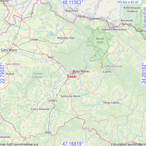
Săsar GPS coordinates[2]
47° 38' 38.616" North, 23° 29' 55.284" East
| Map corner | latitude | longitude |
|---|---|---|
| Upper-left | 48.11563°, | 22.79557° |
| Center: | 47.64406°, | 23.49869° |
| Lower-right: | 47.16819°, | 24.20182° |
| Map W x H: | 105.3×105.3 km | = 65.4×65.4mi |
| max Lat: | 48.23793° ⇑6.1% North |
| Săsar: | 47.64406° |
| min Lat: | ⇓93.9% South 43.65638° |
| min Long | Săsar | max Long |
| 20.31667° | 23.49869° | 29.65403° |
| W 23%⇐ | ⇒77% E |
Elevation
Elevation of Săsar is 183 m = 600 ft, and this is 71.9 m = 236 ft below average elevation for this country.
| Max E: |
1278 m = 4193 ft | 55.8% |
| Avg. | 254.9 m = 836 ft | |
| Săsar | 183 m = 600 ft | |
Min E: |
-2 m = -7 ft | 44.2% |
See also: Romania elevation on elevation.city.
Geographical zone
Săsar is located in North temperate zone (between Tropic of Cancer and the Arctic Circle). Distance of this North polar circle is 2103.7 km =1307.2 mi to North.| Distance of | km | miles | from Săsar |
|---|---|---|---|
| North Pole | 4709.5 | 2926.3 | to North |
| Arctic Circle | 2103.7 | 1307.2 | to North |
| Tropic Cancer | 2691.6 | 1672.5 | to South |
| Equator | 5297.5 | 3291.7 | to South |


Nearby cities:
15 places around Săsar: (largest is in red/bold)
• Baia Mare
5.4 km =3.4 mi,  74°
74°
• Bozânta Mare
4.3 km =2.7 mi,  263°
263°
• Bușag
5.6 km =3.5 mi,  287°
287°
• Băița
6.9 km =4.3 mi,  356°
356°
• Cicârlău
8.9 km =5.5 mi,  306°
306°
• Coltău
5.4 km =3.4 mi,  159°
159°
• Finteușu Mic
9.1 km =5.7 mi,  201°
201°
• Hideaga
8.3 km =5.2 mi,  224°
224°
• Lăpușel
3.2 km =2 mi,  207°
207°
• Mocira
3.1 km =1.9 mi,  140°
140°
• Nistru
9.1 km =5.7 mi,  339°
339°
• Recea
1.8 km =1.1 mi,  131°
131°
• Satu Nou de Jos
6.1 km =3.8 mi,  120°
120°
• Săcălășeni
8.5 km =5.3 mi, 144°
• Tăuții-Măgherăuș
1.3 km =0.8 mi,  299°
299°
Sources, notices
• [Note1] Compared only with cities in Romania existing in our database
• [Src1] Map data: © OpenStreetMap contributors (CC-BY-SA)
• [Src2] Other city data from geonames.org with taken over terms of usage.
• [Src3] Geographical zone / Annual Mean Temperature by Robert A. Rohde @ Wikipedia
