Băița geodata
Băița (Maramureş) is a populated place; located in Romania in Europe/Bucharest (GMT+3) time zone. With population of 1,870 people, there are 2735 cities with bigger population in this country. Compared to other cities in Romania, 95% of cities are located further ↓South; 77% of cities are located further →East and 57.1% of cities have lower elevation than Băița. Note1


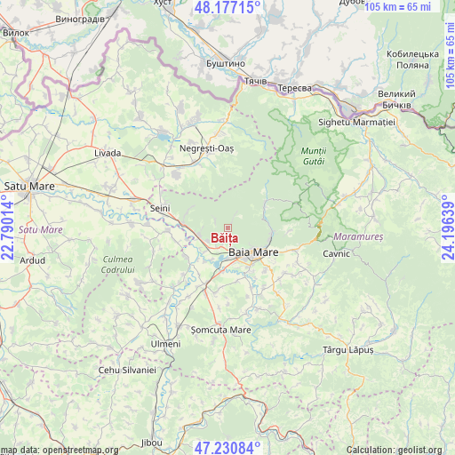
Băița GPS coordinates[2]
47° 42' 22.104" North, 23° 29' 35.736" East
| Map corner | latitude | longitude |
|---|---|---|
| Upper-left | 48.17715°, | 22.79014° |
| Center: | 47.70614°, | 23.49326° |
| Lower-right: | 47.23084°, | 24.19639° |
| Map W x H: | 105.2×105.2 km | = 65.4×65.4mi |
| max Lat: | 48.23793° ⇑5% North |
| Băița: | 47.70614° |
| min Lat: | ⇓95% South 43.65638° |
| min Long | Băița | max Long |
| 20.31667° | 23.49326° | 29.65403° |
| W 23%⇐ | ⇒77% E |
Elevation
Elevation of Băița is 248 m = 814 ft, and this is 6.9 m = 23 ft below average elevation for this country.
| Max E: |
1278 m = 4193 ft | 42.9% |
| Avg. | 254.9 m = 836 ft | |
| Băița | 248 m = 814 ft | |
Min E: |
-2 m = -7 ft | 57.1% |
See also: Romania elevation on elevation.city.
Geographical zone
Băița is located in North temperate zone (between Tropic of Cancer and the Arctic Circle). Distance of this North polar circle is 2096.7 km =1302.8 mi to North.| Distance of | km | miles | from Băița |
|---|---|---|---|
| North Pole | 4702.6 | 2922.1 | to North |
| Arctic Circle | 2096.7 | 1302.8 | to North |
| Tropic Cancer | 2698.5 | 1676.8 | to South |
| Equator | 5304.4 | 3296 | to South |


Nearby cities:
15 places around Băița: (largest is in red/bold)
• Ardusat
11.3 km =7 mi,  236°
236°
• Baia Mare
7.8 km =4.8 mi,  134°
134°
• Borlești
12.2 km =7.6 mi,  255°
255°
• Bozânta Mare
8.3 km =5.2 mi,  207°
207°
• Bușag
7.2 km =4.5 mi,  222°
222°
• Cicârlău
6.9 km =4.3 mi, 256°
• Coltău
12.2 km =7.6 mi,  168°
168°
• Ilba
10.2 km =6.3 mi,  274°
274°
• Lăpușel
9.8 km =6.1 mi,  186°
186°
• Mocira
9.6 km =6 mi, 165°
• Nistru
3.3 km =2.1 mi,  299°
299°
• Recea
8.3 km =5.2 mi, 167°
• Satu Nou de Jos
11.5 km =7.1 mi,  150°
150°
• Săsar
6.9 km =4.3 mi,  176°
176°
• Tăuții-Măgherăuș
6.3 km =3.9 mi, 186°
Sources, notices
• [Note1] Compared only with cities in Romania existing in our database
• [Src1] Map data: © OpenStreetMap contributors (CC-BY-SA)
• [Src2] Other city data from geonames.org with taken over terms of usage.
• [Src3] Geographical zone / Annual Mean Temperature by Robert A. Rohde @ Wikipedia
