Lăpușel geodata
Lăpușel (Maramureş) is a populated place; located in Romania in Europe/Bucharest (GMT+3) time zone. With population of 1,323 people, there are 3477 cities with bigger population in this country. Compared to other cities in Romania, 93.5% of cities are located further ↓South; 77.3% of cities are located further →East and 60.6% of cities have higher elevation than Lăpușel. Note1


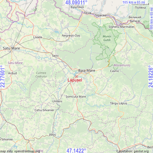
Lăpușel GPS coordinates[2]
47° 37' 5.88" North, 23° 28' 44.868" East
| Map corner | latitude | longitude |
|---|---|---|
| Upper-left | 48.09011°, | 22.77601° |
| Center: | 47.6183°, | 23.47913° |
| Lower-right: | 47.1422°, | 24.18226° |
| Map W x H: | 105.4×105.4 km | = 65.5×65.5mi |
| max Lat: | 48.23793° ⇑6.5% North |
| Lăpușel: | 47.6183° |
| min Lat: | ⇓93.5% South 43.65638° |
| min Long | Lăpușel | max Long |
| 20.31667° | 23.47913° | 29.65403° |
| W 22.7%⇐ | ⇒77.3% E |
Elevation
Elevation of Lăpușel is 164 m = 538 ft, and this is 90.9 m = 298 ft below average elevation for this country.
| Max E: |
1278 m = 4193 ft | 60.6% |
| Avg. | 254.9 m = 836 ft | |
| Lăpușel | 164 m = 538 ft | |
Min E: |
-2 m = -7 ft | 39.4% |
See also: Romania elevation on elevation.city.
Geographical zone
Lăpușel is located in North temperate zone (between Tropic of Cancer and the Arctic Circle). Distance of this North polar circle is 2106.5 km =1308.9 mi to North.| Distance of | km | miles | from Lăpușel |
|---|---|---|---|
| North Pole | 4712.4 | 2928.1 | to North |
| Arctic Circle | 2106.5 | 1308.9 | to North |
| Tropic Cancer | 2688.7 | 1670.7 | to South |
| Equator | 5294.7 | 3290 | to South |


Nearby cities:
15 places around Lăpușel: (largest is in red/bold)
• Baia Mare
8 km =5 mi,  56°
56°
• Bozânta Mare
3.6 km =2.2 mi,  310°
310°
• Bușag
5.9 km =3.7 mi,  319°
319°
• Coltău
4.1 km =2.5 mi,  123°
123°
• Culcea
8.1 km =5 mi,  135°
135°
• Finteușu Mic
5.9 km =3.7 mi,  198°
198°
• Hideaga
5.3 km =3.3 mi,  234°
234°
• Mocira
3.5 km =2.2 mi,  81°
81°
• Mogoșești
7.3 km =4.5 mi,  235°
235°
• Recea
3.3 km =2.1 mi, 59°
• Satu Nou de Jos
6.7 km =4.2 mi,  91°
91°
• Satulung
6.7 km =4.2 mi,  210°
210°
• Săcălășeni
7.6 km =4.7 mi, 122°
• Săsar
3.2 km =2 mi,  27°
27°
• Tăuții-Măgherăuș
3.5 km =2.2 mi,  5°
5°
Sources, notices
• [Note1] Compared only with cities in Romania existing in our database
• [Src1] Map data: © OpenStreetMap contributors (CC-BY-SA)
• [Src2] Other city data from geonames.org with taken over terms of usage.
• [Src3] Geographical zone / Annual Mean Temperature by Robert A. Rohde @ Wikipedia
