Săpânţa geodata
Săpânţa (Maramureş) is a populated place; located in Romania in Europe/Bucharest (GMT+3) time zone. With population of 3,234 people, there are 1597 cities with bigger population in this country. Compared to other cities in Romania, 98.9% of cities are located further ↓South; 74.3% of cities are located further →East and 61% of cities have lower elevation than Săpânţa. Note1


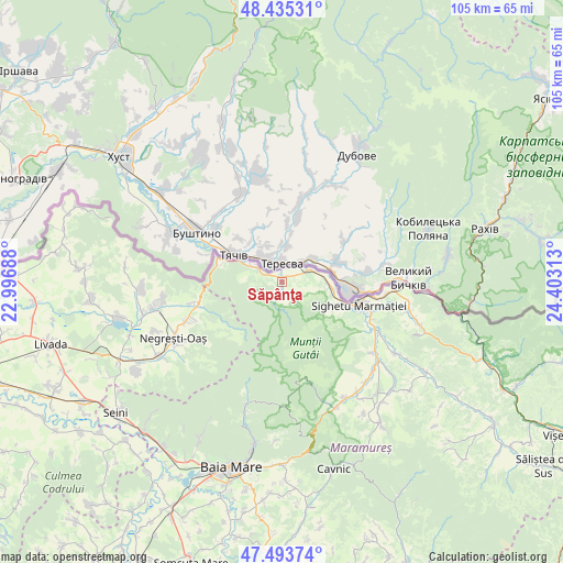
Săpânţa GPS coordinates[2]
47° 58' 0.012" North, 23° 42' 0" East
| Map corner | latitude | longitude |
|---|---|---|
| Upper-left | 48.43531°, | 22.99688° |
| Center: | 47.96667°, | 23.7° |
| Lower-right: | 47.49374°, | 24.40313° |
| Map W x H: | 104.7×104.7 km | = 65.1×65.1mi |
| max Lat: | 48.23793° ⇑1.1% North |
| Săpânţa: | 47.96667° |
| min Lat: | ⇓98.9% South 43.65638° |
| min Long | Săpânţa | max Long |
| 20.31667° | 23.7° | 29.65403° |
| W 25.7%⇐ | ⇒74.3% E |
Elevation
Elevation of Săpânţa is 269 m = 883 ft, and this is 14.1 m = 46 ft above average elevation for this country.
| Max E: |
1278 m = 4193 ft | 39% |
| Săpânţa | 269 m 883 ft | |
| Avg. | 254.9 m = 836 ft | |
Min E: |
-2 m = -7 ft | 61% |
See also: Romania elevation on elevation.city.
Geographical zone
Săpânţa is located in North temperate zone (between Tropic of Cancer and the Arctic Circle). Distance of this North polar circle is 2067.8 km =1284.9 mi to North.| Distance of | km | miles | from Săpânţa |
|---|---|---|---|
| North Pole | 4673.7 | 2904.1 | to North |
| Arctic Circle | 2067.8 | 1284.9 | to North |
| Tropic Cancer | 2727.5 | 1694.8 | to South |
| Equator | 5333.4 | 3314 | to South |


Nearby cities:
15 places around Săpânţa: (largest is in red/bold)
• Berbești
21.9 km =13.6 mi,  126°
126°
• Certeze
18.9 km =11.7 mi,  246°
246°
• Crăciunești
21.1 km =13.1 mi,  93°
93°
• Câmpulung la Tisa
5.8 km =3.6 mi,  67°
67°
• Huta Certeze
16.5 km =10.3 mi, 254°
• Iapa
10.4 km =6.5 mi,  116°
116°
• Lazu Baciului
17.8 km =11.1 mi,  112°
112°
• Moișeni
17.8 km =11.1 mi,  255°
255°
• Remeţi
5.3 km =3.3 mi,  290°
290°
• Sarasău
9.7 km =6 mi,  97°
97°
• Sighetu Marmaţiei
14.4 km =8.9 mi, 105°
• Tisa
19.3 km =12 mi, 96°
• Vadu Izei
14.1 km =8.8 mi, 105°
• Vadu Izei
19.4 km =12.1 mi, 116°
• Valea Cufundoasă
18.5 km =11.5 mi, 100°
Sources, notices
• [Note1] Compared only with cities in Romania existing in our database
• [Src1] Map data: © OpenStreetMap contributors (CC-BY-SA)
• [Src2] Other city data from geonames.org with taken over terms of usage.
• [Src3] Geographical zone / Annual Mean Temperature by Robert A. Rohde @ Wikipedia
