Sanatoriul Agigea geodata
Sanatoriul Agigea (Constanța) is a section of populated place; located in Romania in Europe/Bucharest (GMT+3) time zone. With population of 618 people, there are 6085 cities with bigger population in this country. Compared to other cities in Romania, 95.6% of cities are located further ↑North; 99.3% of cities are located further ←West and 99% of cities have higher elevation than Sanatoriul Agigea. Note1


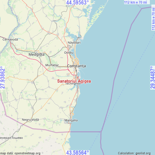
Sanatoriul Agigea GPS coordinates[2]
44° 5' 34.044" North, 28° 38' 30.264" East
| Map corner | latitude | longitude |
|---|---|---|
| Upper-left | 44.59563°, | 27.93862° |
| Center: | 44.09279°, | 28.64174° |
| Lower-right: | 43.58564°, | 29.34487° |
| Map W x H: | 112.3×112.3 km | = 69.8×69.8mi |
| max Lat: | 48.23793° ⇑95.6% North |
| Sanatoriul Agigea: | 44.09279° |
| min Lat: | ⇓4.4% South 43.65638° |
| min Long | Sanatoriul Agig | max Long |
| 20.31667° | 28.64174° | 29.65403° |
| W 99.3%⇐ | ⇒0.7% E |
Elevation
Elevation of Sanatoriul Agigea is 11 m = 36 ft, and this is 243.9 m = 800 ft below average elevation for this country.
| Max E: |
1278 m = 4193 ft | 99% |
| Avg. | 254.9 m = 836 ft | |
| Sanatoriul Agigea | 11 m = 36 ft | |
Min E: |
-2 m = -7 ft | 1% |
See also: Romania elevation on elevation.city.
Geographical zone
Sanatoriul Agigea is located in North temperate zone (between Tropic of Cancer and the Arctic Circle). Distance of this Northern Tropic circle is 2296.7 km =1427.1 mi to South.| Distance of | km | miles | from Sanatoriul Agigea |
|---|---|---|---|
| North Pole | 5104.4 | 3171.7 | to North |
| Arctic Circle | 2498.5 | 1552.5 | to North |
| Tropic Cancer | 2296.7 | 1427.1 | to South |
| Equator | 4902.7 | 3046.4 | to South |


Nearby cities:
15 places around Sanatoriul Agigea: (largest is in red/bold)
• Agigea
2.5 km =1.6 mi,  269°
269°
• Biruința
15.3 km =9.5 mi,  224°
224°
• Constanţa
9.8 km =6.1 mi,  356°
356°
• Costineşti
15.9 km =9.9 mi,  182°
182°
• Cumpăna
6.6 km =4.1 mi,  293°
293°
• Eforie
5.9 km =3.7 mi, 176°
• Eforie Nord
3.2 km =2 mi,  194°
194°
• Eforie Sud
7.8 km =4.8 mi, 175°
• Lazu
3.7 km =2.3 mi,  312°
312°
• Movilița
11.7 km =7.3 mi,  243°
243°
• Palazu Mare
15.5 km =9.6 mi,  347°
347°
• Schitu
16.7 km =10.4 mi, 183°
• Techirghiol
5.8 km =3.6 mi, 215°
• Tuzla
10.3 km =6.4 mi, 183°
• Valu lui Traian
16.2 km =10.1 mi,  300°
300°
Sources, notices
• [Note1] Compared only with cities in Romania existing in our database
• [Src1] Map data: © OpenStreetMap contributors (CC-BY-SA)
• [Src2] Other city data from geonames.org with taken over terms of usage.
• [Src3] Geographical zone / Annual Mean Temperature by Robert A. Rohde @ Wikipedia
