Techirghiol geodata
Techirghiol (Constanța) is a seat of a second-order administrative division; located in Romania in Europe/Bucharest (GMT+3) time zone. With population of 7,083 people, there are 401 cities with bigger population in this country. Compared to other cities in Romania, 96.2% of cities are located further ↑North; 99% of cities are located further ←West and 97.9% of cities have higher elevation than Techirghiol. Note1


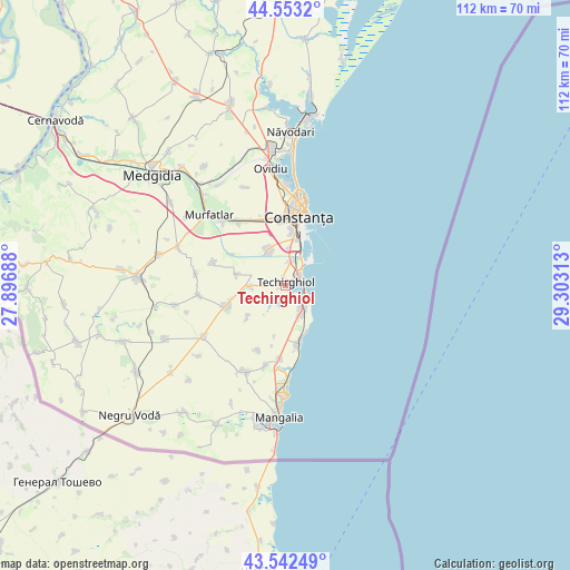
Techirghiol GPS coordinates[2]
44° 3' 0" North, 28° 36' 0" East
| Map corner | latitude | longitude |
|---|---|---|
| Upper-left | 44.5532°, | 27.89688° |
| Center: | 44.05°, | 28.6° |
| Lower-right: | 43.54249°, | 29.30313° |
| Map W x H: | 112.4×112.4 km | = 69.8×69.8mi |
| max Lat: | 48.23793° ⇑96.2% North |
| Techirghiol: | 44.05° |
| min Lat: | ⇓3.8% South 43.65638° |
| min Long | Techirghiol | max Long |
| 20.31667° | 28.6° | 29.65403° |
| W 99%⇐ | ⇒1% E |
Elevation
Elevation of Techirghiol is 18 m = 59 ft, and this is 236.9 m = 777 ft below average elevation for this country.
| Max E: |
1278 m = 4193 ft | 97.9% |
| Avg. | 254.9 m = 836 ft | |
| Techirghiol | 18 m = 59 ft | |
Min E: |
-2 m = -7 ft | 2.1% |
See also: Romania elevation on elevation.city.
Geographical zone
Techirghiol is located in North temperate zone (between Tropic of Cancer and the Arctic Circle). Distance of this Northern Tropic circle is 2292 km =1424.2 mi to South.| Distance of | km | miles | from Techirghiol |
|---|---|---|---|
| North Pole | 5109.2 | 3174.7 | to North |
| Arctic Circle | 2503.3 | 1555.5 | to North |
| Tropic Cancer | 2292 | 1424.2 | to South |
| Equator | 4897.9 | 3043.4 | to South |


Nearby cities:
15 places around Techirghiol: (largest is in red/bold)
• Agigea
4.8 km =3 mi,  10°
10°
• Biruința
9.6 km =6 mi,  230°
230°
• Constanţa
14.8 km =9.2 mi, 10°
• Costineşti
11.4 km =7.1 mi,  166°
166°
• Cumpăna
7.9 km =4.9 mi,  340°
340°
• Eforie
3.9 km =2.4 mi,  106°
106°
• Eforie Nord
3.1 km =1.9 mi,  56°
56°
• Eforie Sud
5 km =3.1 mi,  127°
127°
• Lazu
7.3 km =4.5 mi,  4°
4°
• Movilița
7.1 km =4.4 mi,  265°
265°
• Moșneni
13.9 km =8.6 mi,  203°
203°
• Sanatoriul Agigea
5.8 km =3.6 mi,  35°
35°
• Schitu
12.1 km =7.5 mi, 169°
• Topraisar
12.6 km =7.8 mi,  252°
252°
• Tuzla
6.2 km =3.9 mi,  154°
154°
Sources, notices
• [Note1] Compared only with cities in Romania existing in our database
• [Src1] Map data: © OpenStreetMap contributors (CC-BY-SA)
• [Src2] Other city data from geonames.org with taken over terms of usage.
• [Src3] Geographical zone / Annual Mean Temperature by Robert A. Rohde @ Wikipedia
