Agigea geodata
Agigea (Constanța) is a seat of a second-order administrative division; located in Romania in Europe/Bucharest (GMT+3) time zone. With population of 5,405 people, there are 659 cities with bigger population in this country. Compared to other cities in Romania, 95.6% of cities are located further ↑North; 99.2% of cities are located further ←West and 99.9% of cities have higher elevation than Agigea. Note1


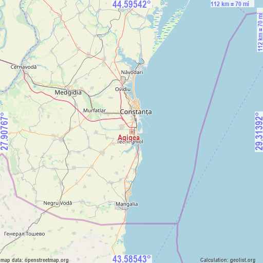
Agigea GPS coordinates[2]
44° 5' 33.288" North, 28° 36' 38.844" East
| Map corner | latitude | longitude |
|---|---|---|
| Upper-left | 44.59542°, | 27.90767° |
| Center: | 44.09258°, | 28.61079° |
| Lower-right: | 43.58543°, | 29.31392° |
| Map W x H: | 112.3×112.3 km | = 69.8×69.8mi |
| max Lat: | 48.23793° ⇑95.6% North |
| Agigea: | 44.09258° |
| min Lat: | ⇓4.4% South 43.65638° |
| min Long | Agigea | max Long |
| 20.31667° | 28.61079° | 29.65403° |
| W 99.2%⇐ | ⇒0.8% E |
Elevation
Elevation of Agigea is 2 m = 7 ft, and this is 252.9 m = 830 ft below average elevation for this country.
| Max E: |
1278 m = 4193 ft | 99.9% |
| Avg. | 254.9 m = 836 ft | |
| Agigea | 2 m = 7 ft | |
Min E: |
-2 m = -7 ft | 0.1% |
See also: Romania elevation on elevation.city.
Geographical zone
Agigea is located in North temperate zone (between Tropic of Cancer and the Arctic Circle). Distance of this Northern Tropic circle is 2296.7 km =1427.1 mi to South.| Distance of | km | miles | from Agigea |
|---|---|---|---|
| North Pole | 5104.4 | 3171.7 | to North |
| Arctic Circle | 2498.5 | 1552.5 | to North |
| Tropic Cancer | 2296.7 | 1427.1 | to South |
| Equator | 4902.6 | 3046.3 | to South |


Nearby cities:
15 places around Agigea: (largest is in red/bold)
• Biruința
13.7 km =8.5 mi,  217°
217°
• Bărăganu
15.3 km =9.5 mi,  268°
268°
• Constanţa
10 km =6.2 mi,  10°
10°
• Cumpăna
4.4 km =2.7 mi,  307°
307°
• Eforie
6.5 km =4 mi,  153°
153°
• Eforie Nord
3.5 km =2.2 mi, 150°
• Eforie Sud
8.3 km =5.2 mi,  158°
158°
• Lazu
2.5 km =1.6 mi,  353°
353°
• Movilița
9.6 km =6 mi,  236°
236°
• Palazu Mare
15.2 km =9.4 mi,  357°
357°
• Sanatoriul Agigea
2.5 km =1.6 mi,  89°
89°
• Techirghiol
4.8 km =3 mi,  190°
190°
• Topraisar
15.4 km =9.6 mi, 236°
• Tuzla
10.5 km =6.5 mi,  170°
170°
• Valu lui Traian
14.1 km =8.8 mi, 305°
Sources, notices
• [Note1] Compared only with cities in Romania existing in our database
• [Src1] Map data: © OpenStreetMap contributors (CC-BY-SA)
• [Src2] Other city data from geonames.org with taken over terms of usage.
• [Src3] Geographical zone / Annual Mean Temperature by Robert A. Rohde @ Wikipedia
