Eforie geodata
Eforie (Constanța) is a seat of a second-order administrative division; located in Romania in Europe/Bucharest (GMT+3) time zone. In our database, there are 7076 cities with bigger population. Compared to other cities in Romania, 96.3% of cities are located further ↑North; 99.3% of cities are located further ←West and 98.7% of cities have higher elevation than Eforie. Note1


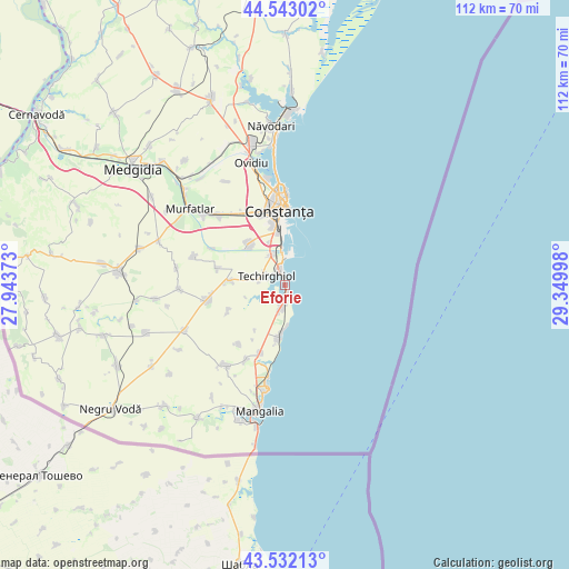
Eforie GPS coordinates[2]
44° 2' 23.028" North, 28° 38' 48.66" East
| Map corner | latitude | longitude |
|---|---|---|
| Upper-left | 44.54302°, | 27.94373° |
| Center: | 44.03973°, | 28.64685° |
| Lower-right: | 43.53213°, | 29.34998° |
| Map W x H: | 112.4×112.4 km | = 69.8×69.8mi |
| max Lat: | 48.23793° ⇑96.3% North |
| Eforie: | 44.03973° |
| min Lat: | ⇓3.7% South 43.65638° |
| min Long | Eforie | max Long |
| 20.31667° | 28.64685° | 29.65403° |
| W 99.3%⇐ | ⇒0.7% E |
Elevation
Elevation of Eforie is 13 m = 43 ft, and this is 241.9 m = 794 ft below average elevation for this country.
| Max E: |
1278 m = 4193 ft | 98.7% |
| Avg. | 254.9 m = 836 ft | |
| Eforie | 13 m = 43 ft | |
Min E: |
-2 m = -7 ft | 1.3% |
See also: Romania elevation on elevation.city.
Geographical zone
Eforie is located in North temperate zone (between Tropic of Cancer and the Arctic Circle). Distance of this Northern Tropic circle is 2290.8 km =1423.4 mi to South.| Distance of | km | miles | from Eforie |
|---|---|---|---|
| North Pole | 5110.3 | 3175.4 | to North |
| Arctic Circle | 2504.4 | 1556.2 | to North |
| Tropic Cancer | 2290.8 | 1423.4 | to South |
| Equator | 4896.8 | 3042.7 | to South |


Nearby cities:
15 places around Eforie: (largest is in red/bold)
• 23 August
14.6 km =9.1 mi,  200°
200°
• Agigea
6.5 km =4 mi,  333°
333°
• Biruința
12.2 km =7.6 mi,  246°
246°
• Constanţa
15.7 km =9.8 mi,  356°
356°
• Costineşti
10 km =6.2 mi,  186°
186°
• Cumpăna
10.7 km =6.6 mi,  323°
323°
• Eforie Nord
3.1 km =1.9 mi,  337°
337°
• Eforie Sud
1.9 km =1.2 mi,  173°
173°
• Lazu
9 km =5.6 mi, 339°
• Movilița
10.9 km =6.8 mi,  273°
273°
• Moșneni
14.9 km =9.3 mi,  218°
218°
• Sanatoriul Agigea
5.9 km =3.7 mi, 356°
• Schitu
10.9 km =6.8 mi, 187°
• Techirghiol
3.9 km =2.4 mi,  286°
286°
• Tuzla
4.5 km =2.8 mi, 193°
Sources, notices
• [Note1] Compared only with cities in Romania existing in our database
• [Src1] Map data: © OpenStreetMap contributors (CC-BY-SA)
• [Src2] Other city data from geonames.org with taken over terms of usage.
• [Src3] Geographical zone / Annual Mean Temperature by Robert A. Rohde @ Wikipedia
