Rebra geodata
Rebra (Bistriţa-Năsăud) is a seat of a second-order administrative division; located in Romania in Europe/Bucharest (GMT+3) time zone. With population of 3,028 people, there are 1740 cities with bigger population in this country. Compared to other cities in Romania, 86.9% of cities are located further ↓South; 60.4% of cities are located further →East and 82.9% of cities have lower elevation than Rebra. Note1


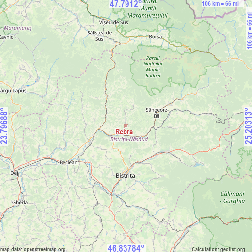
Rebra GPS coordinates[2]
47° 19' 0.012" North, 24° 30' 0" East
| Map corner | latitude | longitude |
|---|---|---|
| Upper-left | 47.7912°, | 23.79688° |
| Center: | 47.31667°, | 24.5° |
| Lower-right: | 46.83784°, | 25.20313° |
| Map W x H: | 106×106 km | = 65.9×65.9mi |
| max Lat: | 48.23793° ⇑13.1% North |
| Rebra: | 47.31667° |
| min Lat: | ⇓86.9% South 43.65638° |
| min Long | Rebra | max Long |
| 20.31667° | 24.5° | 29.65403° |
| W 39.6%⇐ | ⇒60.4% E |
Elevation
Elevation of Rebra is 423 m = 1388 ft, and this is 168.1 m = 552 ft above average elevation for this country.
| Max E: |
1278 m = 4193 ft | 17.1% |
| Rebra | 423 m 1388 ft | |
| Avg. | 254.9 m = 836 ft | |
Min E: |
-2 m = -7 ft | 82.9% |
See also: Romania elevation on elevation.city.
Geographical zone
Rebra is located in North temperate zone (between Tropic of Cancer and the Arctic Circle). Distance of this North polar circle is 2140.1 km =1329.8 mi to North.| Distance of | km | miles | from Rebra |
|---|---|---|---|
| North Pole | 4745.9 | 2949 | to North |
| Arctic Circle | 2140.1 | 1329.8 | to North |
| Tropic Cancer | 2655.2 | 1649.9 | to South |
| Equator | 5261.1 | 3269.1 | to South |


Nearby cities:
15 places around Rebra: (largest is in red/bold)
• Coşbuc
9.8 km =6.1 mi,  303°
303°
• Dumitra
11.2 km =7 mi,  186°
186°
• Feldru
8.4 km =5.2 mi,  116°
116°
• Gersa I
3.7 km =2.3 mi,  306°
306°
• Ilva Mică
12.6 km =7.8 mi,  90°
90°
• Liviu Rebreanu
7.5 km =4.7 mi,  222°
222°
• Lușca
8.2 km =5.1 mi,  239°
239°
• Nepos
5 km =3.1 mi,  150°
150°
• Năsăud
8.4 km =5.2 mi, 243°
• Parva
10 km =6.2 mi,  22°
22°
• Rebrişoara
5.3 km =3.3 mi,  225°
225°
• Runcu Salvei
13.5 km =8.4 mi,  282°
282°
• Salva
11.5 km =7.1 mi,  260°
260°
• Slătinița
12.7 km =7.9 mi,  170°
170°
• Valea Borcutului
13.2 km =8.2 mi,  60°
60°
Sources, notices
• [Note1] Compared only with cities in Romania existing in our database
• [Src1] Map data: © OpenStreetMap contributors (CC-BY-SA)
• [Src2] Other city data from geonames.org with taken over terms of usage.
• [Src3] Geographical zone / Annual Mean Temperature by Robert A. Rohde @ Wikipedia
