Parva geodata
Parva (Bistriţa-Năsăud) is a seat of a second-order administrative division; located in Romania in Europe/Bucharest (GMT+3) time zone. With population of 2,611 people, there are 2057 cities with bigger population in this country. Compared to other cities in Romania, 88.8% of cities are located further ↓South; 59.6% of cities are located further →East and 94.8% of cities have lower elevation than Parva. Note1


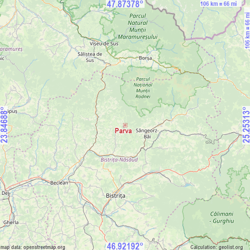
Parva GPS coordinates[2]
47° 24' 0" North, 24° 33' 0" East
| Map corner | latitude | longitude |
|---|---|---|
| Upper-left | 47.87378°, | 23.84688° |
| Center: | 47.4°, | 24.55° |
| Lower-right: | 46.92192°, | 25.25313° |
| Map W x H: | 105.8×105.8 km | = 65.7×65.7mi |
| max Lat: | 48.23793° ⇑11.2% North |
| Parva: | 47.4° |
| min Lat: | ⇓88.8% South 43.65638° |
| min Long | Parva | max Long |
| 20.31667° | 24.55° | 29.65403° |
| W 40.4%⇐ | ⇒59.6% E |
Elevation
Elevation of Parva is 622 m = 2041 ft, and this is 367.1 m = 1204 ft above average elevation for this country.
| Max E: |
1278 m = 4193 ft | 5.2% |
| Parva | 622 m 2041 ft | |
| Avg. | 254.9 m = 836 ft | |
Min E: |
-2 m = -7 ft | 94.8% |
See also: Romania elevation on elevation.city.
Geographical zone
Parva is located in North temperate zone (between Tropic of Cancer and the Arctic Circle). Distance of this North polar circle is 2130.8 km =1324 mi to North.| Distance of | km | miles | from Parva |
|---|---|---|---|
| North Pole | 4736.7 | 2943.2 | to North |
| Arctic Circle | 2130.8 | 1324 | to North |
| Tropic Cancer | 2664.5 | 1655.6 | to South |
| Equator | 5270.4 | 3274.9 | to South |


Nearby cities:
15 places around Parva: (largest is in red/bold)
• Bichigiu
16.1 km =10 mi,  280°
280°
• Cormaia
10.7 km =6.6 mi,  110°
110°
• Coşbuc
12.6 km =7.8 mi,  252°
252°
• Feldru
13.5 km =8.4 mi,  163°
163°
• Gersa I
9.7 km =6 mi,  223°
223°
• Ilva Mică
12.8 km =8 mi,  136°
136°
• Măieru
15.1 km =9.4 mi,  90°
90°
• Nepos
13.7 km =8.5 mi,  185°
185°
• Poiana Ilvei
15.1 km =9.4 mi, 108°
• Rebra
10 km =6.2 mi,  202°
202°
• Rebrişoara
15 km =9.3 mi,  210°
210°
• Sângeorz-Băi
9.8 km =6.1 mi, 110°
• Telciu
11.9 km =7.4 mi,  288°
288°
• Telcișor
10 km =6.2 mi,  312°
312°
• Valea Borcutului
8.2 km =5.1 mi, 109°
Sources, notices
• [Note1] Compared only with cities in Romania existing in our database
• [Src1] Map data: © OpenStreetMap contributors (CC-BY-SA)
• [Src2] Other city data from geonames.org with taken over terms of usage.
• [Src3] Geographical zone / Annual Mean Temperature by Robert A. Rohde @ Wikipedia
